You are here: Home > Network List > TA - USArray Transportable Network (new EarthScope stations) Stations List
> Station F26K Sheenjek River, AK, USA > Earthquake Result Viewer
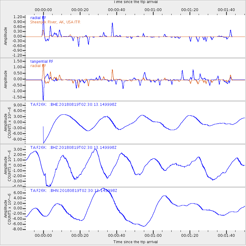
F26K Sheenjek River, AK, USA - Earthquake Result Viewer
*The percent match for this event was below the threshold and hence no stack was calculated.
| Earthquake location: |
Fiji Islands Region |
| Earthquake latitude/longitude: |
-18.3/-178.4 |
| Earthquake time(UTC): |
2018/08/19 (231) 02:18:52 GMT |
| Earthquake Depth: |
618 km |
| Earthquake Magnitude: |
5.7 mb |
| Earthquake Catalog/Contributor: |
NEIC PDE/us |
|
| Network: |
TA USArray Transportable Network (new EarthScope stations) |
| Station: |
F26K Sheenjek River, AK, USA |
| Lat/Lon: |
67.69 N/144.15 W |
| Elevation: |
683 m |
|
| Distance: |
89.3 deg |
| Az: |
12.394 deg |
| Baz: |
212.292 deg |
| Ray Param: |
$rayparam |
*The percent match for this event was below the threshold and hence was not used in the summary stack. |
|
| Radial Match: |
45.638542 % |
| Radial Bump: |
254 |
| Transverse Match: |
59.469734 % |
| Transverse Bump: |
346 |
| SOD ConfigId: |
13570011 |
| Insert Time: |
2019-04-30 21:43:10.307 +0000 |
| GWidth: |
2.5 |
| Max Bumps: |
400 |
| Tol: |
0.001 |
|
Signal To Noise
| Channel | StoN | STA | LTA |
| TA:F26K: :BHZ:20180819T02:30:13.149998Z | 2.255154 | 3.5339012E-6 | 1.5670333E-6 |
| TA:F26K: :BHN:20180819T02:30:13.149998Z | 1.0306737 | 3.296213E-6 | 3.198115E-6 |
| TA:F26K: :BHE:20180819T02:30:13.149998Z | 0.68561673 | 2.8653192E-6 | 4.179185E-6 |
| Arrivals |
| Ps | |
| PpPs | |
| PsPs/PpSs | |


