You are here: Home > Network List > TA - USArray Transportable Network (new EarthScope stations) Stations List
> Station Z17A San Carlos High School, San Carlos, AZ, USA > Earthquake Result Viewer
Z17A San Carlos High School, San Carlos, AZ, USA - Earthquake Result Viewer
| Earthquake location: |
Andreanof Islands, Aleutian Is. |
| Earthquake latitude/longitude: |
51.9/-179.2 |
| Earthquake time(UTC): |
2008/04/16 (107) 05:54:19 GMT |
| Earthquake Depth: |
13 km |
| Earthquake Magnitude: |
6.1 MB, 6.5 MS, 6.6 MW, 6.6 MW |
| Earthquake Catalog/Contributor: |
WHDF/NEIC |
|
| Network: |
TA USArray Transportable Network (new EarthScope stations) |
| Station: |
Z17A San Carlos High School, San Carlos, AZ, USA |
| Lat/Lon: |
33.30 N/110.47 W |
| Elevation: |
846 m |
|
| Distance: |
51.9 deg |
| Az: |
82.703 deg |
| Baz: |
312.763 deg |
| Ray Param: |
0.06711969 |
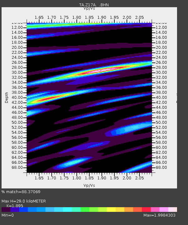
| Estimated Moho Depth: |
29.0 km |
| Estimated Crust Vp/Vs: |
1.89 |
| Assumed Crust Vp: |
6.276 km/s |
| Estimated Crust Vs: |
3.312 km/s |
| Estimated Crust Poisson's Ratio: |
0.31 |
|
| Radial Match: |
88.37069 % |
| Radial Bump: |
400 |
| Transverse Match: |
82.382195 % |
| Transverse Bump: |
400 |
| SOD ConfigId: |
2504 |
| Insert Time: |
2010-03-06 14:22:27.827 +0000 |
| GWidth: |
2.5 |
| Max Bumps: |
400 |
| Tol: |
0.001 |
|

Signal To Noise
| Channel | StoN | STA | LTA |
| TA:Z17A: :BHN:20080416T06:02:56.674009Z | 3.7923863 | 9.810312E-7 | 2.5868442E-7 |
| TA:Z17A: :BHE:20080416T06:02:56.674009Z | 1.6917877 | 3.8872986E-7 | 2.2977461E-7 |
| TA:Z17A: :BHZ:20080416T06:02:56.674009Z | 0.91727865 | 3.28485E-7 | 3.581082E-7 |
| Arrivals |
| Ps | 4.3 SECOND |
| PpPs | 13 SECOND |
| PsPs/PpSs | 17 SECOND |


