You are here: Home > Network List > 2H - Interim Broadband Monitoring of the Mount Erebus Volcano Stations List
> Station NAUS Mt Erebus site NAUS > Earthquake Result Viewer
NAUS Mt Erebus site NAUS - Earthquake Result Viewer
| Earthquake location: |
Sumbawa Region, Indonesia |
| Earthquake latitude/longitude: |
-8.3/116.6 |
| Earthquake time(UTC): |
2018/08/19 (231) 04:10:21 GMT |
| Earthquake Depth: |
7.9 km |
| Earthquake Magnitude: |
6.3 Mww |
| Earthquake Catalog/Contributor: |
NEIC PDE/us |
|
| Network: |
2H Interim Broadband Monitoring of the Mount Erebus Volcano |
| Station: |
NAUS Mt Erebus site NAUS |
| Lat/Lon: |
77.52 S/167.15 E |
| Elevation: |
3590 m |
|
| Distance: |
73.9 deg |
| Az: |
169.932 deg |
| Baz: |
307.292 deg |
| Ray Param: |
0.052688878 |
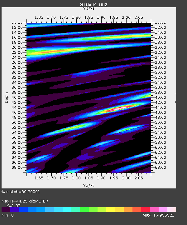
| Estimated Moho Depth: |
44.25 km |
| Estimated Crust Vp/Vs: |
1.97 |
| Assumed Crust Vp: |
6.183 km/s |
| Estimated Crust Vs: |
3.138 km/s |
| Estimated Crust Poisson's Ratio: |
0.33 |
|
| Radial Match: |
80.30001 % |
| Radial Bump: |
400 |
| Transverse Match: |
65.761566 % |
| Transverse Bump: |
400 |
| SOD ConfigId: |
13570011 |
| Insert Time: |
2019-04-30 21:44:57.988 +0000 |
| GWidth: |
2.5 |
| Max Bumps: |
400 |
| Tol: |
0.001 |
|

Signal To Noise
| Channel | StoN | STA | LTA |
| 2H:NAUS: :HHZ:20180819T04:21:25.593987Z | 16.466785 | 3.549471E-6 | 2.1555337E-7 |
| 2H:NAUS: :HH1:20180819T04:21:25.593987Z | 2.9593513 | 1.7301129E-6 | 5.8462575E-7 |
| 2H:NAUS: :HH2:20180819T04:21:25.593987Z | 3.5210755 | 1.1787753E-6 | 3.3477707E-7 |
| Arrivals |
| Ps | 7.1 SECOND |
| PpPs | 21 SECOND |
| PsPs/PpSs | 28 SECOND |


