You are here: Home > Network List > AK - Alaska Regional Network Stations List
> Station BARK Barkley Ridge, AK, USA > Earthquake Result Viewer
BARK Barkley Ridge, AK, USA - Earthquake Result Viewer
| Earthquake location: |
Fiji Islands Region |
| Earthquake latitude/longitude: |
-17.0/-178.0 |
| Earthquake time(UTC): |
2018/08/19 (231) 04:28:58 GMT |
| Earthquake Depth: |
416 km |
| Earthquake Magnitude: |
6.8 mww |
| Earthquake Catalog/Contributor: |
NEIC PDE/us |
|
| Network: |
AK Alaska Regional Network |
| Station: |
BARK Barkley Ridge, AK, USA |
| Lat/Lon: |
60.40 N/142.49 W |
| Elevation: |
1390 m |
|
| Distance: |
82.3 deg |
| Az: |
16.93 deg |
| Baz: |
214.15 deg |
| Ray Param: |
0.045867518 |
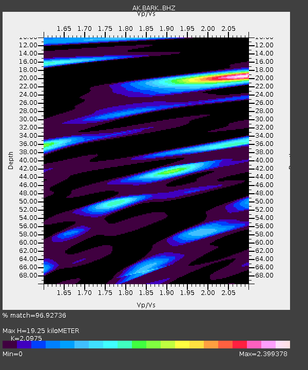
| Estimated Moho Depth: |
19.25 km |
| Estimated Crust Vp/Vs: |
2.10 |
| Assumed Crust Vp: |
6.566 km/s |
| Estimated Crust Vs: |
3.13 km/s |
| Estimated Crust Poisson's Ratio: |
0.35 |
|
| Radial Match: |
96.92736 % |
| Radial Bump: |
373 |
| Transverse Match: |
88.940186 % |
| Transverse Bump: |
400 |
| SOD ConfigId: |
13570011 |
| Insert Time: |
2019-04-30 21:48:46.144 +0000 |
| GWidth: |
2.5 |
| Max Bumps: |
400 |
| Tol: |
0.001 |
|

Signal To Noise
| Channel | StoN | STA | LTA |
| AK:BARK: :BHZ:20180819T04:40:03.928027Z | 9.436697 | 3.3257209E-6 | 3.5242425E-7 |
| AK:BARK: :BHN:20180819T04:40:03.928027Z | 6.343317 | 1.8759097E-6 | 2.9573008E-7 |
| AK:BARK: :BHE:20180819T04:40:03.928027Z | 7.958783 | 2.5055024E-6 | 3.1480974E-7 |
| Arrivals |
| Ps | 3.3 SECOND |
| PpPs | 8.9 SECOND |
| PsPs/PpSs | 12 SECOND |


