You are here: Home > Network List > AK - Alaska Regional Network Stations List
> Station GLB Gilahina Butte, AK, USA > Earthquake Result Viewer
GLB Gilahina Butte, AK, USA - Earthquake Result Viewer
| Earthquake location: |
Fiji Islands Region |
| Earthquake latitude/longitude: |
-17.0/-178.0 |
| Earthquake time(UTC): |
2018/08/19 (231) 04:28:58 GMT |
| Earthquake Depth: |
416 km |
| Earthquake Magnitude: |
6.8 mww |
| Earthquake Catalog/Contributor: |
NEIC PDE/us |
|
| Network: |
AK Alaska Regional Network |
| Station: |
GLB Gilahina Butte, AK, USA |
| Lat/Lon: |
61.44 N/143.81 W |
| Elevation: |
855 m |
|
| Distance: |
82.8 deg |
| Az: |
15.807 deg |
| Baz: |
212.853 deg |
| Ray Param: |
0.045519885 |
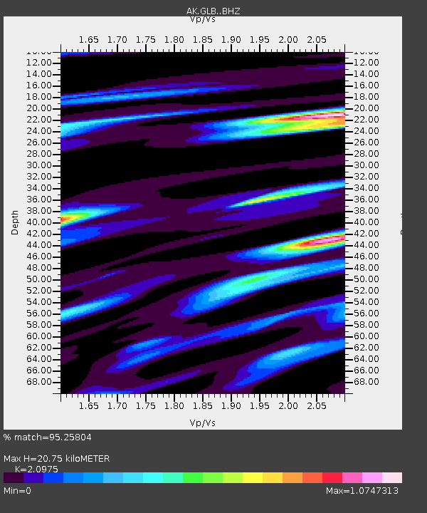
| Estimated Moho Depth: |
20.75 km |
| Estimated Crust Vp/Vs: |
2.10 |
| Assumed Crust Vp: |
6.566 km/s |
| Estimated Crust Vs: |
3.13 km/s |
| Estimated Crust Poisson's Ratio: |
0.35 |
|
| Radial Match: |
95.25804 % |
| Radial Bump: |
400 |
| Transverse Match: |
82.285545 % |
| Transverse Bump: |
400 |
| SOD ConfigId: |
13570011 |
| Insert Time: |
2019-04-30 21:49:04.271 +0000 |
| GWidth: |
2.5 |
| Max Bumps: |
400 |
| Tol: |
0.001 |
|

Signal To Noise
| Channel | StoN | STA | LTA |
| AK:GLB: :BHZ:20180819T04:40:06.528003Z | 2.7773829 | 1.872896E-6 | 6.7433837E-7 |
| AK:GLB: :BHN:20180819T04:40:06.528003Z | 2.7224643 | 5.836968E-7 | 2.1440016E-7 |
| AK:GLB: :BHE:20180819T04:40:06.528003Z | 0.80402946 | 4.963104E-7 | 6.172789E-7 |
| Arrivals |
| Ps | 3.5 SECOND |
| PpPs | 9.6 SECOND |
| PsPs/PpSs | 13 SECOND |


