You are here: Home > Network List > AK - Alaska Regional Network Stations List
> Station MCAR McCarthy VSAT, AK, USA > Earthquake Result Viewer
MCAR McCarthy VSAT, AK, USA - Earthquake Result Viewer
| Earthquake location: |
Fiji Islands Region |
| Earthquake latitude/longitude: |
-17.0/-178.0 |
| Earthquake time(UTC): |
2018/08/19 (231) 04:28:58 GMT |
| Earthquake Depth: |
416 km |
| Earthquake Magnitude: |
6.8 mww |
| Earthquake Catalog/Contributor: |
NEIC PDE/us |
|
| Network: |
AK Alaska Regional Network |
| Station: |
MCAR McCarthy VSAT, AK, USA |
| Lat/Lon: |
61.38 N/143.02 W |
| Elevation: |
447 m |
|
| Distance: |
82.9 deg |
| Az: |
16.159 deg |
| Baz: |
213.588 deg |
| Ray Param: |
0.045408946 |
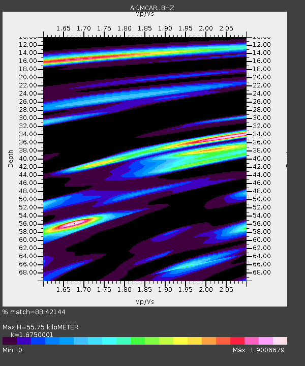
| Estimated Moho Depth: |
55.75 km |
| Estimated Crust Vp/Vs: |
1.68 |
| Assumed Crust Vp: |
6.566 km/s |
| Estimated Crust Vs: |
3.92 km/s |
| Estimated Crust Poisson's Ratio: |
0.22 |
|
| Radial Match: |
88.42144 % |
| Radial Bump: |
400 |
| Transverse Match: |
72.48817 % |
| Transverse Bump: |
400 |
| SOD ConfigId: |
13570011 |
| Insert Time: |
2019-04-30 21:49:16.463 +0000 |
| GWidth: |
2.5 |
| Max Bumps: |
400 |
| Tol: |
0.001 |
|

Signal To Noise
| Channel | StoN | STA | LTA |
| AK:MCAR: :BHZ:20180819T04:40:07.34801Z | 4.9093127 | 1.7730935E-6 | 3.611694E-7 |
| AK:MCAR: :BHN:20180819T04:40:07.34801Z | 3.2304876 | 8.656696E-7 | 2.6796872E-7 |
| AK:MCAR: :BHE:20180819T04:40:07.34801Z | 2.2213945 | 9.723962E-7 | 4.3774133E-7 |
| Arrivals |
| Ps | 5.9 SECOND |
| PpPs | 22 SECOND |
| PsPs/PpSs | 28 SECOND |


