You are here: Home > Network List > TA - USArray Transportable Network (new EarthScope stations) Stations List
> Station Z17A San Carlos High School, San Carlos, AZ, USA > Earthquake Result Viewer
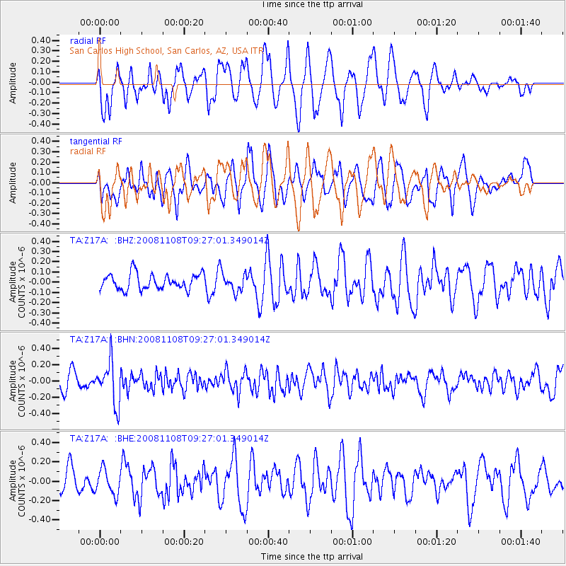
Z17A San Carlos High School, San Carlos, AZ, USA - Earthquake Result Viewer
*The percent match for this event was below the threshold and hence no stack was calculated.
| Earthquake location: |
Tonga Islands |
| Earthquake latitude/longitude: |
-15.2/-174.2 |
| Earthquake time(UTC): |
2008/11/08 (313) 09:15:51 GMT |
| Earthquake Depth: |
140 km |
| Earthquake Magnitude: |
5.5 MW, 5.3 MB |
| Earthquake Catalog/Contributor: |
WHDF/NEIC |
|
| Network: |
TA USArray Transportable Network (new EarthScope stations) |
| Station: |
Z17A San Carlos High School, San Carlos, AZ, USA |
| Lat/Lon: |
33.30 N/110.47 W |
| Elevation: |
846 m |
|
| Distance: |
77.6 deg |
| Az: |
50.273 deg |
| Baz: |
242.438 deg |
| Ray Param: |
$rayparam |
*The percent match for this event was below the threshold and hence was not used in the summary stack. |
|
| Radial Match: |
61.35486 % |
| Radial Bump: |
400 |
| Transverse Match: |
51.81768 % |
| Transverse Bump: |
400 |
| SOD ConfigId: |
2658 |
| Insert Time: |
2010-03-06 14:23:22.209 +0000 |
| GWidth: |
2.5 |
| Max Bumps: |
400 |
| Tol: |
0.001 |
|
Signal To Noise
| Channel | StoN | STA | LTA |
| TA:Z17A: :BHN:20081108T09:27:01.349014Z | 2.4700327 | 2.6722293E-7 | 1.0818598E-7 |
| TA:Z17A: :BHE:20081108T09:27:01.349014Z | 1.0265284 | 1.3168888E-7 | 1.2828568E-7 |
| TA:Z17A: :BHZ:20081108T09:27:01.349014Z | 1.0829072 | 8.276703E-8 | 7.64304E-8 |
| Arrivals |
| Ps | |
| PpPs | |
| PsPs/PpSs | |


