You are here: Home > Network List > TA - USArray Transportable Network (new EarthScope stations) Stations List
> Station Z17A San Carlos High School, San Carlos, AZ, USA > Earthquake Result Viewer
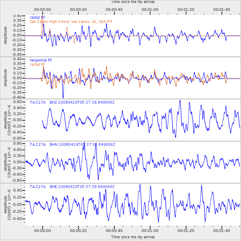
Z17A San Carlos High School, San Carlos, AZ, USA - Earthquake Result Viewer
*The percent match for this event was below the threshold and hence no stack was calculated.
| Earthquake location: |
Hokkaido, Japan Region |
| Earthquake latitude/longitude: |
41.5/142.0 |
| Earthquake time(UTC): |
2008/04/29 (120) 05:26:04 GMT |
| Earthquake Depth: |
47 km |
| Earthquake Magnitude: |
5.5 MB, 5.2 MS, 5.8 MW, 5.8 MW |
| Earthquake Catalog/Contributor: |
WHDF/NEIC |
|
| Network: |
TA USArray Transportable Network (new EarthScope stations) |
| Station: |
Z17A San Carlos High School, San Carlos, AZ, USA |
| Lat/Lon: |
33.30 N/110.47 W |
| Elevation: |
846 m |
|
| Distance: |
80.2 deg |
| Az: |
54.166 deg |
| Baz: |
313.31 deg |
| Ray Param: |
$rayparam |
*The percent match for this event was below the threshold and hence was not used in the summary stack. |
|
| Radial Match: |
60.93297 % |
| Radial Bump: |
400 |
| Transverse Match: |
70.279076 % |
| Transverse Bump: |
398 |
| SOD ConfigId: |
2504 |
| Insert Time: |
2010-03-06 14:23:29.245 +0000 |
| GWidth: |
2.5 |
| Max Bumps: |
400 |
| Tol: |
0.001 |
|
Signal To Noise
| Channel | StoN | STA | LTA |
| TA:Z17A: :BHN:20080429T05:37:38.849006Z | 2.4943755 | 2.474722E-7 | 9.921208E-8 |
| TA:Z17A: :BHE:20080429T05:37:38.849006Z | 0.37786567 | 7.76061E-8 | 2.0538015E-7 |
| TA:Z17A: :BHZ:20080429T05:37:38.849006Z | 0.9794085 | 1.712375E-7 | 1.7483768E-7 |
| Arrivals |
| Ps | |
| PpPs | |
| PsPs/PpSs | |


