You are here: Home > Network List > TA - USArray Transportable Network (new EarthScope stations) Stations List
> Station Z17A San Carlos High School, San Carlos, AZ, USA > Earthquake Result Viewer
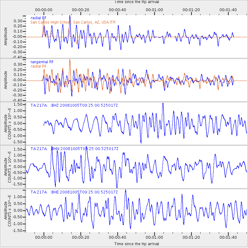
Z17A San Carlos High School, San Carlos, AZ, USA - Earthquake Result Viewer
*The percent match for this event was below the threshold and hence no stack was calculated.
| Earthquake location: |
Kermadec Islands, New Zealand |
| Earthquake latitude/longitude: |
-30.2/-177.2 |
| Earthquake time(UTC): |
2008/10/05 (279) 09:12:36 GMT |
| Earthquake Depth: |
10 km |
| Earthquake Magnitude: |
5.8 MB, 6.2 MS, 6.2 MW, 6.1 MW |
| Earthquake Catalog/Contributor: |
WHDF/NEIC |
|
| Network: |
TA USArray Transportable Network (new EarthScope stations) |
| Station: |
Z17A San Carlos High School, San Carlos, AZ, USA |
| Lat/Lon: |
33.30 N/110.47 W |
| Elevation: |
846 m |
|
| Distance: |
89.2 deg |
| Az: |
50.292 deg |
| Baz: |
232.689 deg |
| Ray Param: |
$rayparam |
*The percent match for this event was below the threshold and hence was not used in the summary stack. |
|
| Radial Match: |
63.4269 % |
| Radial Bump: |
400 |
| Transverse Match: |
71.12497 % |
| Transverse Bump: |
400 |
| SOD ConfigId: |
2556 |
| Insert Time: |
2010-03-06 14:23:43.609 +0000 |
| GWidth: |
2.5 |
| Max Bumps: |
400 |
| Tol: |
0.001 |
|
Signal To Noise
| Channel | StoN | STA | LTA |
| TA:Z17A: :BHN:20081005T09:25:00.525017Z | 2.8338559 | 7.020199E-7 | 2.4772606E-7 |
| TA:Z17A: :BHE:20081005T09:25:00.525017Z | 1.0627846 | 3.321122E-7 | 3.124925E-7 |
| TA:Z17A: :BHZ:20081005T09:25:00.525017Z | 1.5101173 | 4.873404E-7 | 3.2271691E-7 |
| Arrivals |
| Ps | |
| PpPs | |
| PsPs/PpSs | |


