You are here: Home > Network List > CI - Caltech Regional Seismic Network Stations List
> Station IRM Iron Mountain Pumping Station, Eagle Mtn., CA, USA > Earthquake Result Viewer
IRM Iron Mountain Pumping Station, Eagle Mtn., CA, USA - Earthquake Result Viewer
| Earthquake location: |
Fiji Islands Region |
| Earthquake latitude/longitude: |
-17.0/-178.0 |
| Earthquake time(UTC): |
2018/08/19 (231) 04:28:58 GMT |
| Earthquake Depth: |
416 km |
| Earthquake Magnitude: |
6.8 mww |
| Earthquake Catalog/Contributor: |
NEIC PDE/us |
|
| Network: |
CI Caltech Regional Seismic Network |
| Station: |
IRM Iron Mountain Pumping Station, Eagle Mtn., CA, USA |
| Lat/Lon: |
34.16 N/115.15 W |
| Elevation: |
567 m |
|
| Distance: |
78.5 deg |
| Az: |
48.874 deg |
| Baz: |
240.374 deg |
| Ray Param: |
0.048419394 |
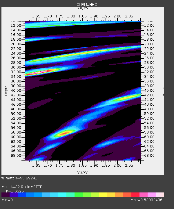
| Estimated Moho Depth: |
32.0 km |
| Estimated Crust Vp/Vs: |
1.65 |
| Assumed Crust Vp: |
6.276 km/s |
| Estimated Crust Vs: |
3.798 km/s |
| Estimated Crust Poisson's Ratio: |
0.21 |
|
| Radial Match: |
95.69241 % |
| Radial Bump: |
230 |
| Transverse Match: |
78.98975 % |
| Transverse Bump: |
326 |
| SOD ConfigId: |
13570011 |
| Insert Time: |
2019-04-30 21:52:16.513 +0000 |
| GWidth: |
2.5 |
| Max Bumps: |
400 |
| Tol: |
0.001 |
|

Signal To Noise
| Channel | StoN | STA | LTA |
| CI:IRM: :HHZ:20180819T04:39:44.218005Z | 7.6690884 | 4.406044E-6 | 5.745199E-7 |
| CI:IRM: :HHN:20180819T04:39:44.218005Z | 2.2922728 | 6.5553644E-7 | 2.8597663E-7 |
| CI:IRM: :HHE:20180819T04:39:44.218005Z | 7.0594606 | 1.6067114E-6 | 2.275969E-7 |
| Arrivals |
| Ps | 3.4 SECOND |
| PpPs | 13 SECOND |
| PsPs/PpSs | 17 SECOND |


