You are here: Home > Network List > TA - USArray Transportable Network (new EarthScope stations) Stations List
> Station Y17A Roosevelt, AZ, USA > Earthquake Result Viewer
Y17A Roosevelt, AZ, USA - Earthquake Result Viewer
| Earthquake location: |
Fiji Islands Region |
| Earthquake latitude/longitude: |
-17.3/-177.3 |
| Earthquake time(UTC): |
2008/07/19 (201) 22:39:52 GMT |
| Earthquake Depth: |
391 km |
| Earthquake Magnitude: |
5.9 MB, 6.4 MW, 6.4 MW |
| Earthquake Catalog/Contributor: |
WHDF/NEIC |
|
| Network: |
TA USArray Transportable Network (new EarthScope stations) |
| Station: |
Y17A Roosevelt, AZ, USA |
| Lat/Lon: |
33.70 N/110.84 W |
| Elevation: |
866 m |
|
| Distance: |
81.1 deg |
| Az: |
50.683 deg |
| Baz: |
242.415 deg |
| Ray Param: |
0.046733793 |
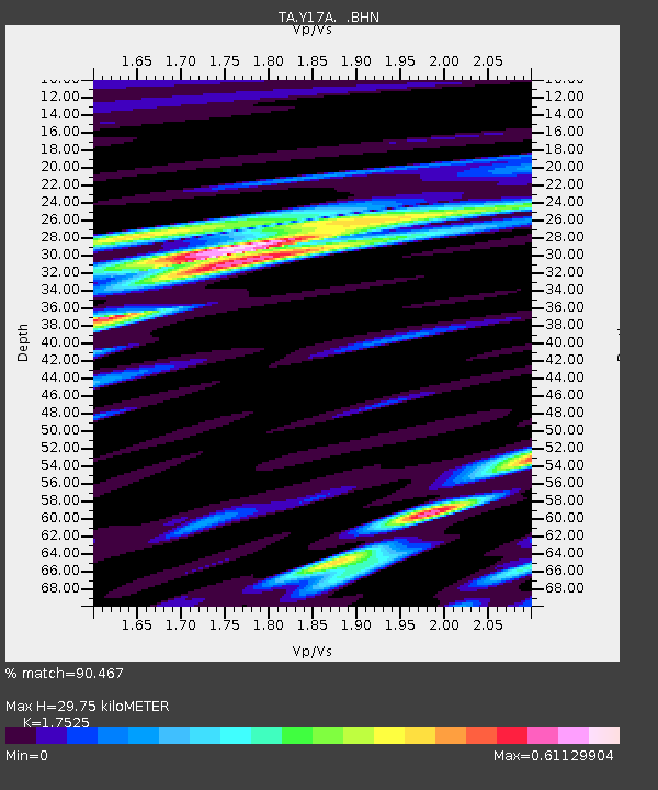
| Estimated Moho Depth: |
29.75 km |
| Estimated Crust Vp/Vs: |
1.75 |
| Assumed Crust Vp: |
6.276 km/s |
| Estimated Crust Vs: |
3.581 km/s |
| Estimated Crust Poisson's Ratio: |
0.26 |
|
| Radial Match: |
90.467 % |
| Radial Bump: |
400 |
| Transverse Match: |
65.00148 % |
| Transverse Bump: |
400 |
| SOD ConfigId: |
2504 |
| Insert Time: |
2010-03-06 14:23:51.215 +0000 |
| GWidth: |
2.5 |
| Max Bumps: |
400 |
| Tol: |
0.001 |
|

Signal To Noise
| Channel | StoN | STA | LTA |
| TA:Y17A: :BHN:20080719T22:50:54.475024Z | 14.9520445 | 1.6220773E-6 | 1.0848532E-7 |
| TA:Y17A: :BHE:20080719T22:50:54.475024Z | 3.588544 | 2.9097447E-7 | 8.1084266E-8 |
| TA:Y17A: :BHZ:20080719T22:50:54.475024Z | 12.151819 | 5.5472634E-7 | 4.5649656E-8 |
| Arrivals |
| Ps | 3.7 SECOND |
| PpPs | 13 SECOND |
| PsPs/PpSs | 16 SECOND |


