You are here: Home > Network List > CN - Canadian National Seismograph Network Stations List
> Station INK INUVIK, NT > Earthquake Result Viewer
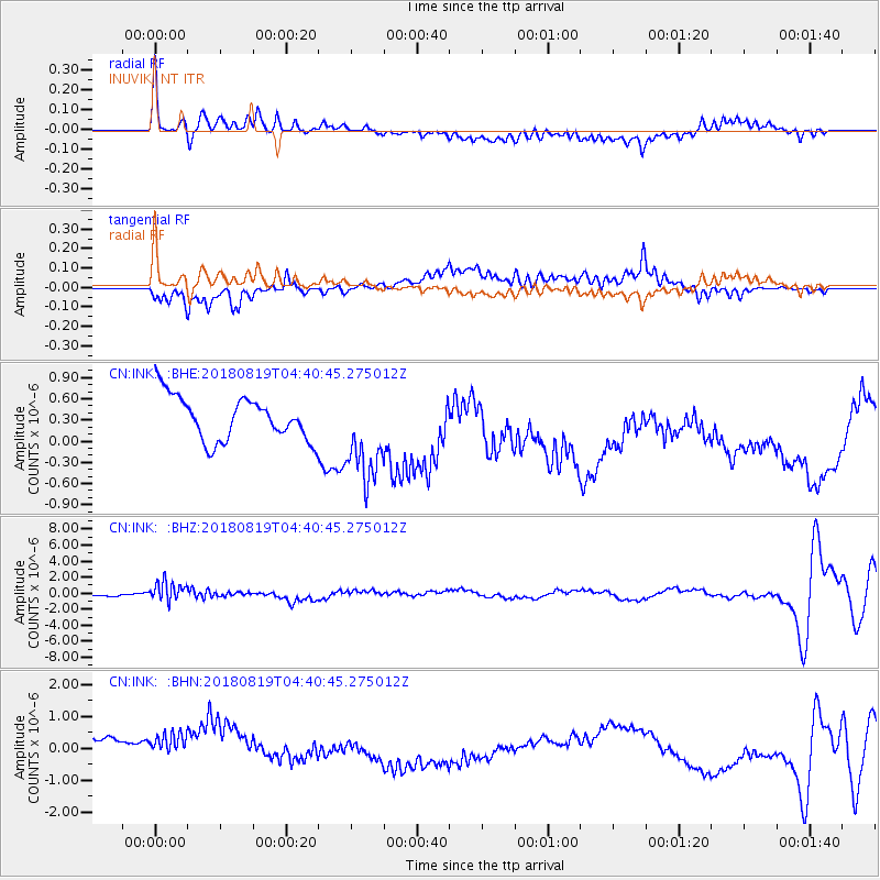
INK INUVIK, NT - Earthquake Result Viewer
*The percent match for this event was below the threshold and hence no stack was calculated.
| Earthquake location: |
Fiji Islands Region |
| Earthquake latitude/longitude: |
-17.0/-178.0 |
| Earthquake time(UTC): |
2018/08/19 (231) 04:28:58 GMT |
| Earthquake Depth: |
416 km |
| Earthquake Magnitude: |
6.8 mww |
| Earthquake Catalog/Contributor: |
NEIC PDE/us |
|
| Network: |
CN Canadian National Seismograph Network |
| Station: |
INK INUVIK, NT |
| Lat/Lon: |
68.31 N/133.53 W |
| Elevation: |
44 m |
|
| Distance: |
90.9 deg |
| Az: |
15.109 deg |
| Baz: |
222.138 deg |
| Ray Param: |
$rayparam |
*The percent match for this event was below the threshold and hence was not used in the summary stack. |
|
| Radial Match: |
69.29928 % |
| Radial Bump: |
400 |
| Transverse Match: |
44.26966 % |
| Transverse Bump: |
400 |
| SOD ConfigId: |
13570011 |
| Insert Time: |
2019-04-30 21:52:51.392 +0000 |
| GWidth: |
2.5 |
| Max Bumps: |
400 |
| Tol: |
0.001 |
|
Signal To Noise
| Channel | StoN | STA | LTA |
| CN:INK: :BHZ:20180819T04:40:45.275012Z | 7.934554 | 1.2210978E-6 | 1.5389621E-7 |
| CN:INK: :BHN:20180819T04:40:45.275012Z | 0.9802013 | 1.0819477E-6 | 1.1038015E-6 |
| CN:INK: :BHE:20180819T04:40:45.275012Z | 2.1431873 | 6.5971756E-7 | 3.0782078E-7 |
| Arrivals |
| Ps | |
| PpPs | |
| PsPs/PpSs | |


