You are here: Home > Network List > CN - Canadian National Seismograph Network Stations List
> Station YUK7 Dusty Glacier, YT, CA > Earthquake Result Viewer
YUK7 Dusty Glacier, YT, CA - Earthquake Result Viewer
| Earthquake location: |
Fiji Islands Region |
| Earthquake latitude/longitude: |
-17.0/-178.0 |
| Earthquake time(UTC): |
2018/08/19 (231) 04:28:58 GMT |
| Earthquake Depth: |
416 km |
| Earthquake Magnitude: |
6.8 mww |
| Earthquake Catalog/Contributor: |
NEIC PDE/us |
|
| Network: |
CN Canadian National Seismograph Network |
| Station: |
YUK7 Dusty Glacier, YT, CA |
| Lat/Lon: |
60.53 N/138.14 W |
| Elevation: |
1992 m |
|
| Distance: |
83.6 deg |
| Az: |
18.608 deg |
| Baz: |
218.138 deg |
| Ray Param: |
0.0449183 |
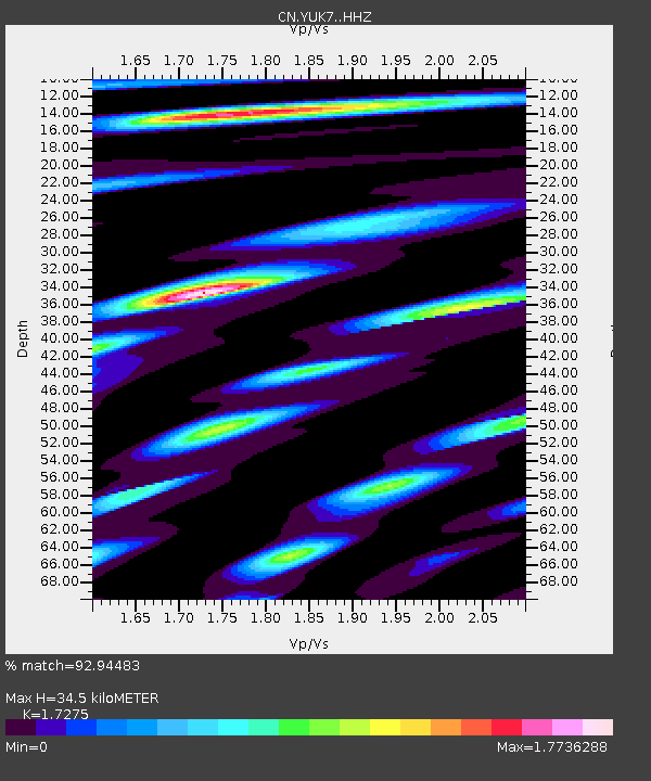
| Estimated Moho Depth: |
34.5 km |
| Estimated Crust Vp/Vs: |
1.73 |
| Assumed Crust Vp: |
6.566 km/s |
| Estimated Crust Vs: |
3.801 km/s |
| Estimated Crust Poisson's Ratio: |
0.25 |
|
| Radial Match: |
92.94483 % |
| Radial Bump: |
400 |
| Transverse Match: |
82.96346 % |
| Transverse Bump: |
400 |
| SOD ConfigId: |
13570011 |
| Insert Time: |
2019-04-30 21:53:06.160 +0000 |
| GWidth: |
2.5 |
| Max Bumps: |
400 |
| Tol: |
0.001 |
|

Signal To Noise
| Channel | StoN | STA | LTA |
| CN:YUK7: :HHZ:20180819T04:40:10.859973Z | 7.2135954 | 2.0646828E-6 | 2.8622105E-7 |
| CN:YUK7: :HHN:20180819T04:40:10.859973Z | 2.14912 | 9.93252E-7 | 4.6216684E-7 |
| CN:YUK7: :HHE:20180819T04:40:10.859973Z | 1.6727511 | 5.642496E-7 | 3.3731834E-7 |
| Arrivals |
| Ps | 3.9 SECOND |
| PpPs | 14 SECOND |
| PsPs/PpSs | 18 SECOND |


