You are here: Home > Network List > TA - USArray Transportable Network (new EarthScope stations) Stations List
> Station Y17A Roosevelt, AZ, USA > Earthquake Result Viewer
Y17A Roosevelt, AZ, USA - Earthquake Result Viewer
| Earthquake location: |
Vanuatu Islands |
| Earthquake latitude/longitude: |
-14.8/168.0 |
| Earthquake time(UTC): |
2008/11/07 (312) 07:19:35 GMT |
| Earthquake Depth: |
13 km |
| Earthquake Magnitude: |
6.0 MB, 6.3 MS, 6.4 MW, 6.4 MW |
| Earthquake Catalog/Contributor: |
WHDF/NEIC |
|
| Network: |
TA USArray Transportable Network (new EarthScope stations) |
| Station: |
Y17A Roosevelt, AZ, USA |
| Lat/Lon: |
33.70 N/110.84 W |
| Elevation: |
866 m |
|
| Distance: |
90.9 deg |
| Az: |
55.47 deg |
| Baz: |
252.873 deg |
| Ray Param: |
0.04163863 |
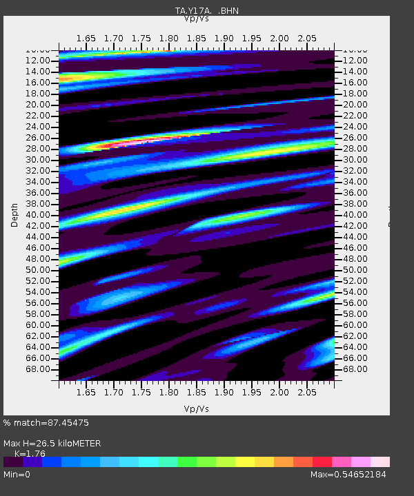
| Estimated Moho Depth: |
26.5 km |
| Estimated Crust Vp/Vs: |
1.76 |
| Assumed Crust Vp: |
6.276 km/s |
| Estimated Crust Vs: |
3.566 km/s |
| Estimated Crust Poisson's Ratio: |
0.26 |
|
| Radial Match: |
87.45475 % |
| Radial Bump: |
400 |
| Transverse Match: |
62.298046 % |
| Transverse Bump: |
400 |
| SOD ConfigId: |
2658 |
| Insert Time: |
2010-03-06 14:24:06.447 +0000 |
| GWidth: |
2.5 |
| Max Bumps: |
400 |
| Tol: |
0.001 |
|

Signal To Noise
| Channel | StoN | STA | LTA |
| TA:Y17A: :BHN:20081107T07:32:07.475015Z | 3.6852705 | 3.6166804E-7 | 9.81388E-8 |
| TA:Y17A: :BHE:20081107T07:32:07.475015Z | 1.3057327 | 9.8616624E-8 | 7.552589E-8 |
| TA:Y17A: :BHZ:20081107T07:32:07.475015Z | 1.6407785 | 1.0781694E-7 | 6.5710836E-8 |
| Arrivals |
| Ps | 3.3 SECOND |
| PpPs | 11 SECOND |
| PsPs/PpSs | 15 SECOND |


