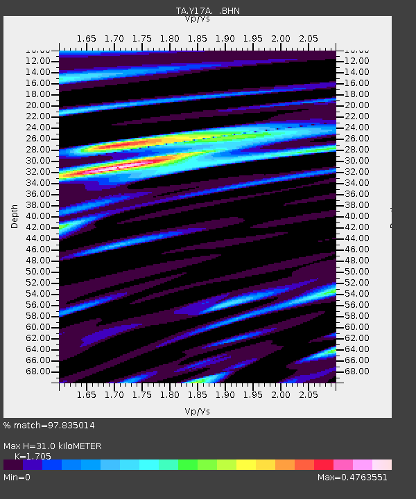
Y17A Roosevelt, AZ, USA - Earthquake Result Viewer
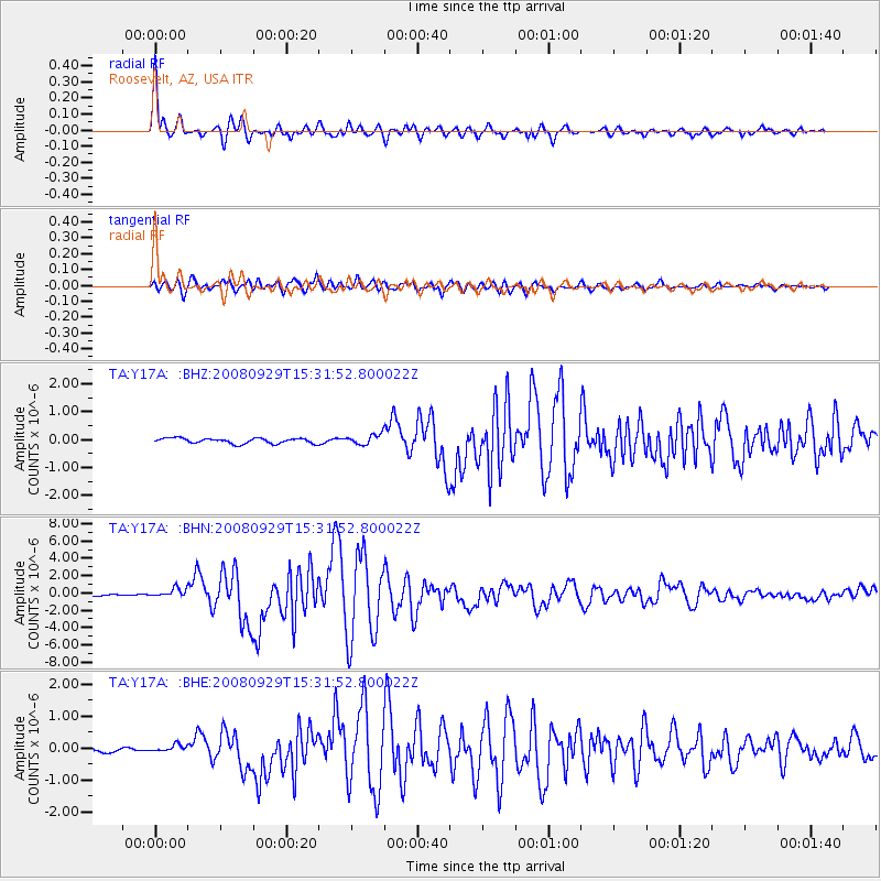
Earthquake location: Kermadec Islands, New Zealand
Earthquake latitude/longitude: -29.8/-177.7
Earthquake time(UTC): 2008/09/29 (273) 15:19:31 GMT
Earthquake Depth: 36 km
Earthquake Magnitude: 6.5 MB, 6.7 MS, 7.0 MW, 7.0 MW
Earthquake Catalog/Contributor: WHDF/NEIC
Network: TA USArray Transportable Network (new EarthScope stations)
Station: Y17A Roosevelt, AZ, USA
Lat/Lon: 33.70 N/110.84 W
Elevation: 866 m
Distance: 89.3 deg
Az: 50.047 deg
Baz: 233.087 deg
Ray Param: 0.041914552
Estimated Moho Depth: 31.0 km
Estimated Crust Vp/Vs: 1.71
Assumed Crust Vp: 6.276 km/s
Estimated Crust Vs: 3.681 km/s
Estimated Crust Poisson's Ratio: 0.24
Radial Match: 97.835014 %
Radial Bump: 400
Transverse Match: 94.08323 %
Transverse Bump: 400
SOD ConfigId: 2560
Insert Time: 2010-03-06 14:24:16.145 +0000
GWidth: 2.5
Max Bumps: 400
Tol: 0.001

Signal To Noise

ChannelStoNSTALTA
TA:Y17A: :BHN:20080929T15:31:52.800022Z6.1518035.088202E-78.271075E-8
TA:Y17A: :BHE:20080929T15:31:52.800022Z2.09769271.2006414E-75.723629E-8
TA:Y17A: :BHZ:20080929T15:31:52.800022Z2.0159181.8629238E-79.2410694E-8
Arrivals
Ps3.6 SECOND
PpPs13 SECOND
PsPs/PpSs17 SECOND