You are here: Home > Network List > TA - USArray Transportable Network (new EarthScope stations) Stations List
> Station Y17A Roosevelt, AZ, USA > Earthquake Result Viewer
Y17A Roosevelt, AZ, USA - Earthquake Result Viewer
| Earthquake location: |
Near Coast Of Northern Chile |
| Earthquake latitude/longitude: |
-23.1/-70.6 |
| Earthquake time(UTC): |
2007/11/17 (321) 17:54:32 GMT |
| Earthquake Depth: |
15 km |
| Earthquake Magnitude: |
5.6 MB, 5.6 MS, 5.8 MW, 5.8 MW |
| Earthquake Catalog/Contributor: |
WHDF/NEIC |
|
| Network: |
TA USArray Transportable Network (new EarthScope stations) |
| Station: |
Y17A Roosevelt, AZ, USA |
| Lat/Lon: |
33.70 N/110.84 W |
| Elevation: |
866 m |
|
| Distance: |
68.2 deg |
| Az: |
324.546 deg |
| Baz: |
140.148 deg |
| Ray Param: |
0.05643716 |
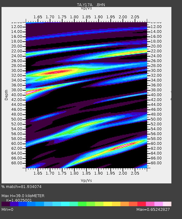
| Estimated Moho Depth: |
39.0 km |
| Estimated Crust Vp/Vs: |
1.60 |
| Assumed Crust Vp: |
6.276 km/s |
| Estimated Crust Vs: |
3.916 km/s |
| Estimated Crust Poisson's Ratio: |
0.18 |
|
| Radial Match: |
81.934074 % |
| Radial Bump: |
400 |
| Transverse Match: |
74.68105 % |
| Transverse Bump: |
380 |
| SOD ConfigId: |
2564 |
| Insert Time: |
2010-03-06 14:24:30.530 +0000 |
| GWidth: |
2.5 |
| Max Bumps: |
400 |
| Tol: |
0.001 |
|

Signal To Noise
| Channel | StoN | STA | LTA |
| TA:Y17A: :BHN:20071117T18:05:01.425029Z | 0.84347683 | 1.5455473E-7 | 1.832353E-7 |
| TA:Y17A: :BHE:20071117T18:05:01.425029Z | 1.3028828 | 1.5873933E-7 | 1.21837E-7 |
| TA:Y17A: :BHZ:20071117T18:05:01.425029Z | 2.9525661 | 3.3515872E-7 | 1.13514375E-7 |
| Arrivals |
| Ps | 3.9 SECOND |
| PpPs | 16 SECOND |
| PsPs/PpSs | 19 SECOND |


