You are here: Home > Network List > TA - USArray Transportable Network (new EarthScope stations) Stations List
> Station Y17A Roosevelt, AZ, USA > Earthquake Result Viewer
Y17A Roosevelt, AZ, USA - Earthquake Result Viewer
| Earthquake location: |
South Of Mariana Islands |
| Earthquake latitude/longitude: |
10.5/145.7 |
| Earthquake time(UTC): |
2007/09/30 (273) 02:08:30 GMT |
| Earthquake Depth: |
14 km |
| Earthquake Magnitude: |
6.4 MB, 7.1 MS, 6.9 MW, 6.9 MW |
| Earthquake Catalog/Contributor: |
WHDF/NEIC |
|
| Network: |
TA USArray Transportable Network (new EarthScope stations) |
| Station: |
Y17A Roosevelt, AZ, USA |
| Lat/Lon: |
33.70 N/110.84 W |
| Elevation: |
866 m |
|
| Distance: |
95.2 deg |
| Az: |
54.515 deg |
| Baz: |
286.121 deg |
| Ray Param: |
0.04083722 |
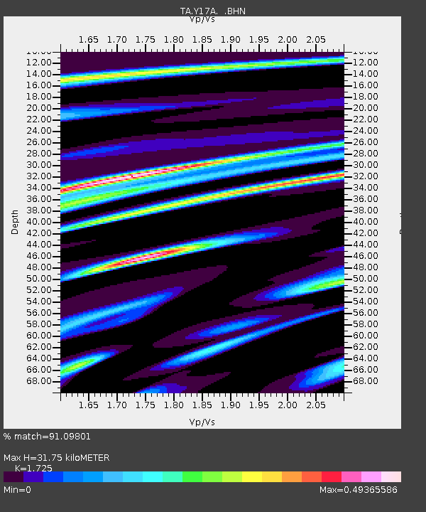
| Estimated Moho Depth: |
31.75 km |
| Estimated Crust Vp/Vs: |
1.73 |
| Assumed Crust Vp: |
6.276 km/s |
| Estimated Crust Vs: |
3.638 km/s |
| Estimated Crust Poisson's Ratio: |
0.25 |
|
| Radial Match: |
91.09801 % |
| Radial Bump: |
384 |
| Transverse Match: |
78.79039 % |
| Transverse Bump: |
400 |
| SOD ConfigId: |
2564 |
| Insert Time: |
2010-03-06 14:24:39.566 +0000 |
| GWidth: |
2.5 |
| Max Bumps: |
400 |
| Tol: |
0.001 |
|

Signal To Noise
| Channel | StoN | STA | LTA |
| TA:Y17A: :BHN:20070930T02:21:21.500017Z | 1.1886804 | 7.4537326E-8 | 6.270594E-8 |
| TA:Y17A: :BHE:20070930T02:21:21.500017Z | 1.0574458 | 9.204748E-8 | 8.7047E-8 |
| TA:Y17A: :BHZ:20070930T02:21:21.500017Z | 2.2461193 | 1.9097956E-7 | 8.502645E-8 |
| Arrivals |
| Ps | 3.7 SECOND |
| PpPs | 14 SECOND |
| PsPs/PpSs | 17 SECOND |


