You are here: Home > Network List > S - Seismographs in Schools Projects Stations List
> Station AUBRN Burnie High School, Burnie, TAS > Earthquake Result Viewer
AUBRN Burnie High School, Burnie, TAS - Earthquake Result Viewer
| Earthquake location: |
Fiji Islands Region |
| Earthquake latitude/longitude: |
-17.0/-178.0 |
| Earthquake time(UTC): |
2018/08/19 (231) 04:28:58 GMT |
| Earthquake Depth: |
416 km |
| Earthquake Magnitude: |
6.8 mww |
| Earthquake Catalog/Contributor: |
NEIC PDE/us |
|
| Network: |
S Seismographs in Schools Projects |
| Station: |
AUBRN Burnie High School, Burnie, TAS |
| Lat/Lon: |
41.04 S/145.87 E |
| Elevation: |
10 m |
|
| Distance: |
39.2 deg |
| Az: |
224.815 deg |
| Baz: |
63.085 deg |
| Ray Param: |
0.073244005 |
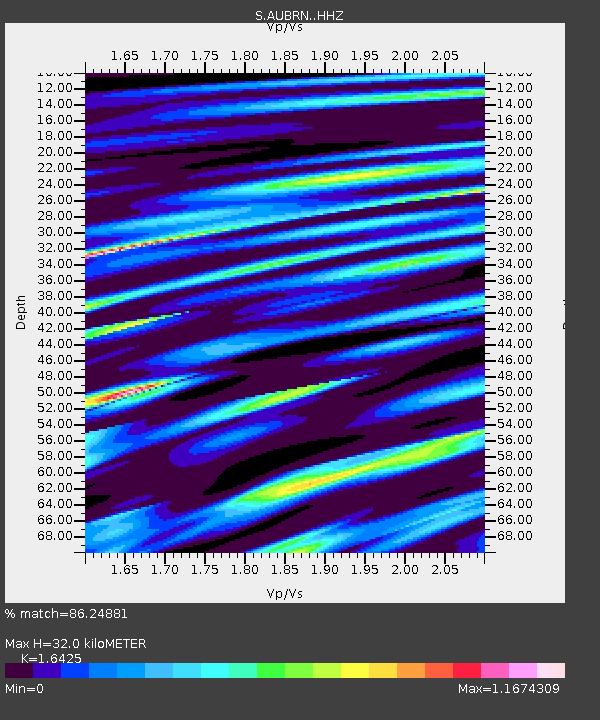
| Estimated Moho Depth: |
32.0 km |
| Estimated Crust Vp/Vs: |
1.64 |
| Assumed Crust Vp: |
6.477 km/s |
| Estimated Crust Vs: |
3.943 km/s |
| Estimated Crust Poisson's Ratio: |
0.21 |
|
| Radial Match: |
86.24881 % |
| Radial Bump: |
400 |
| Transverse Match: |
50.65243 % |
| Transverse Bump: |
318 |
| SOD ConfigId: |
13570011 |
| Insert Time: |
2019-04-30 21:55:51.571 +0000 |
| GWidth: |
2.5 |
| Max Bumps: |
400 |
| Tol: |
0.001 |
|

Signal To Noise
| Channel | StoN | STA | LTA |
| S:AUBRN: :HHZ:20180819T04:35:18.640002Z | 2.3543644 | 2.4014596E-5 | 1.0200034E-5 |
| S:AUBRN: :HHN:20180819T04:35:18.640002Z | 3.5404575 | 1.1496622E-5 | 3.247214E-6 |
| S:AUBRN: :HHE:20180819T04:35:18.640002Z | 1.5324314 | 9.257844E-6 | 6.0412776E-6 |
| Arrivals |
| Ps | 3.4 SECOND |
| PpPs | 12 SECOND |
| PsPs/PpSs | 16 SECOND |


