You are here: Home > Network List > SN - Southern Great Basin Network Stations List
> Station HEL Hell's Gate, California w84 > Earthquake Result Viewer
HEL Hell's Gate, California w84 - Earthquake Result Viewer
| Earthquake location: |
Fiji Islands Region |
| Earthquake latitude/longitude: |
-17.0/-178.0 |
| Earthquake time(UTC): |
2018/08/19 (231) 04:28:58 GMT |
| Earthquake Depth: |
416 km |
| Earthquake Magnitude: |
6.8 mww |
| Earthquake Catalog/Contributor: |
NEIC PDE/us |
|
| Network: |
SN Southern Great Basin Network |
| Station: |
HEL Hell's Gate, California w84 |
| Lat/Lon: |
36.72 N/116.98 W |
| Elevation: |
747 m |
|
| Distance: |
78.5 deg |
| Az: |
45.847 deg |
| Baz: |
238.713 deg |
| Ray Param: |
0.04841306 |
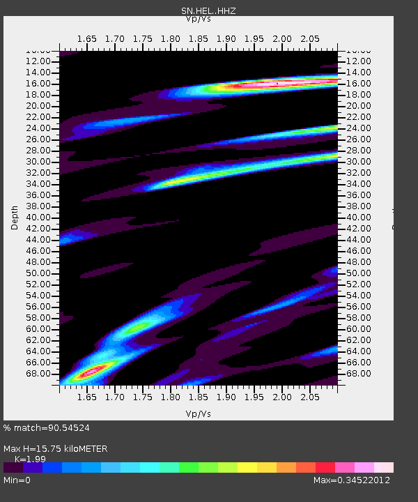
| Estimated Moho Depth: |
15.75 km |
| Estimated Crust Vp/Vs: |
1.99 |
| Assumed Crust Vp: |
6.279 km/s |
| Estimated Crust Vs: |
3.155 km/s |
| Estimated Crust Poisson's Ratio: |
0.33 |
|
| Radial Match: |
90.54524 % |
| Radial Bump: |
368 |
| Transverse Match: |
89.97157 % |
| Transverse Bump: |
400 |
| SOD ConfigId: |
13570011 |
| Insert Time: |
2019-04-30 21:56:07.100 +0000 |
| GWidth: |
2.5 |
| Max Bumps: |
400 |
| Tol: |
0.001 |
|

Signal To Noise
| Channel | StoN | STA | LTA |
| SN:HEL: :HHZ:20180819T04:39:44.278003Z | 5.0607843 | 3.2377015E-6 | 6.3976285E-7 |
| SN:HEL: :HHN:20180819T04:39:44.278003Z | 2.2602692 | 1.1596068E-6 | 5.1303925E-7 |
| SN:HEL: :HHE:20180819T04:39:44.278003Z | 7.521829 | 1.3354334E-6 | 1.7754104E-7 |
| Arrivals |
| Ps | 2.5 SECOND |
| PpPs | 7.3 SECOND |
| PsPs/PpSs | 9.9 SECOND |


