You are here: Home > Network List > TA - USArray Transportable Network (new EarthScope stations) Stations List
> Station G18K Tagagawik, AK, USA > Earthquake Result Viewer
G18K Tagagawik, AK, USA - Earthquake Result Viewer
| Earthquake location: |
Fiji Islands Region |
| Earthquake latitude/longitude: |
-17.0/-178.0 |
| Earthquake time(UTC): |
2018/08/19 (231) 04:28:58 GMT |
| Earthquake Depth: |
416 km |
| Earthquake Magnitude: |
6.8 mww |
| Earthquake Catalog/Contributor: |
NEIC PDE/us |
|
| Network: |
TA USArray Transportable Network (new EarthScope stations) |
| Station: |
G18K Tagagawik, AK, USA |
| Lat/Lon: |
65.89 N/158.65 W |
| Elevation: |
484 m |
|
| Distance: |
83.9 deg |
| Az: |
7.877 deg |
| Baz: |
198.623 deg |
| Ray Param: |
0.044731613 |
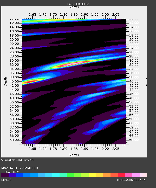
| Estimated Moho Depth: |
31.5 km |
| Estimated Crust Vp/Vs: |
1.84 |
| Assumed Crust Vp: |
6.1 km/s |
| Estimated Crust Vs: |
3.324 km/s |
| Estimated Crust Poisson's Ratio: |
0.29 |
|
| Radial Match: |
84.70246 % |
| Radial Bump: |
348 |
| Transverse Match: |
48.05362 % |
| Transverse Bump: |
351 |
| SOD ConfigId: |
13570011 |
| Insert Time: |
2019-04-30 21:56:40.953 +0000 |
| GWidth: |
2.5 |
| Max Bumps: |
400 |
| Tol: |
0.001 |
|

Signal To Noise
| Channel | StoN | STA | LTA |
| TA:G18K: :BHZ:20180819T04:40:12.200Z | 4.5258083 | 1.7346993E-6 | 3.8329046E-7 |
| TA:G18K: :BHN:20180819T04:40:12.200Z | 1.2711079 | 4.1139845E-7 | 3.2365344E-7 |
| TA:G18K: :BHE:20180819T04:40:12.200Z | 1.3111671 | 3.996386E-7 | 3.047961E-7 |
| Arrivals |
| Ps | 4.4 SECOND |
| PpPs | 14 SECOND |
| PsPs/PpSs | 19 SECOND |


