You are here: Home > Network List > TA - USArray Transportable Network (new EarthScope stations) Stations List
> Station HARP HAARP, Gakona, AK, USA > Earthquake Result Viewer
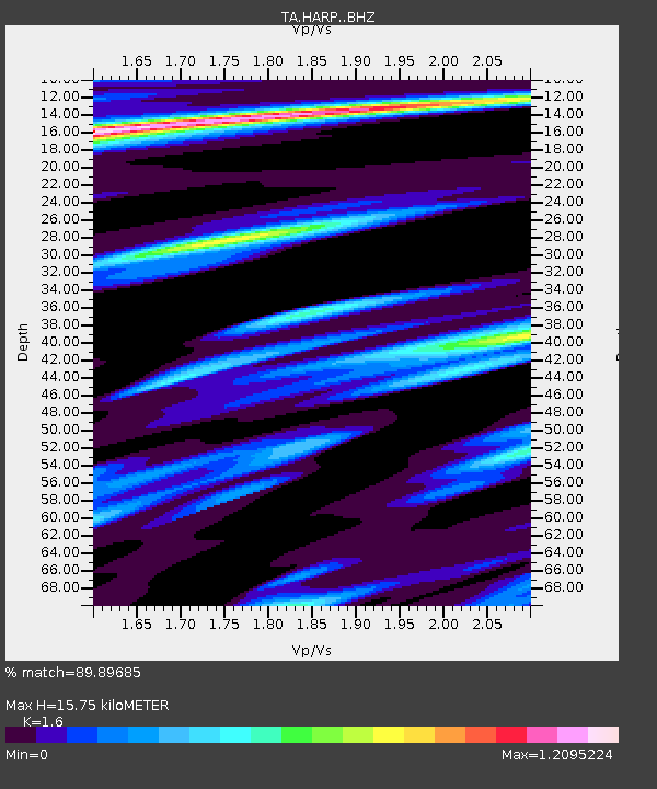
HARP HAARP, Gakona, AK, USA - Earthquake Result Viewer
| Earthquake location: |
Fiji Islands Region |
| Earthquake latitude/longitude: |
-17.0/-178.0 |
| Earthquake time(UTC): |
2018/08/19 (231) 04:28:58 GMT |
| Earthquake Depth: |
416 km |
| Earthquake Magnitude: |
6.8 mww |
| Earthquake Catalog/Contributor: |
NEIC PDE/us |
|
| Network: |
TA USArray Transportable Network (new EarthScope stations) |
| Station: |
HARP HAARP, Gakona, AK, USA |
| Lat/Lon: |
62.40 N/145.16 W |
| Elevation: |
581 m |
|
| Distance: |
83.3 deg |
| Az: |
14.75 deg |
| Baz: |
211.54 deg |
| Ray Param: |
0.045189135 |
| Estimated Moho Depth: |
15.75 km |
| Estimated Crust Vp/Vs: |
1.60 |
| Assumed Crust Vp: |
6.566 km/s |
| Estimated Crust Vs: |
4.104 km/s |
| Estimated Crust Poisson's Ratio: |
0.18 |
|
| Radial Match: |
89.89685 % |
| Radial Bump: |
400 |
| Transverse Match: |
73.2345 % |
| Transverse Bump: |
400 |
| SOD ConfigId: |
13570011 |
| Insert Time: |
2019-04-30 21:56:53.631 +0000 |
| GWidth: |
2.5 |
| Max Bumps: |
400 |
| Tol: |
0.001 |
|

Signal To Noise
| Channel | StoN | STA | LTA |
| TA:HARP: :BHZ:20180819T04:40:08.924976Z | 4.6651654 | 2.874848E-6 | 6.1623706E-7 |
| TA:HARP: :BHN:20180819T04:40:08.924976Z | 1.6695561 | 1.3115405E-6 | 7.8556235E-7 |
| TA:HARP: :BHE:20180819T04:40:08.924976Z | 1.8055017 | 1.3185571E-6 | 7.302996E-7 |
| Arrivals |
| Ps | 1.5 SECOND |
| PpPs | 6.1 SECOND |
| PsPs/PpSs | 7.5 SECOND |


