You are here: Home > Network List > TA - USArray Transportable Network (new EarthScope stations) Stations List
> Station J18K Innoko River, AK, USA > Earthquake Result Viewer
J18K Innoko River, AK, USA - Earthquake Result Viewer
| Earthquake location: |
Fiji Islands Region |
| Earthquake latitude/longitude: |
-17.0/-178.0 |
| Earthquake time(UTC): |
2018/08/19 (231) 04:28:58 GMT |
| Earthquake Depth: |
416 km |
| Earthquake Magnitude: |
6.8 mww |
| Earthquake Catalog/Contributor: |
NEIC PDE/us |
|
| Network: |
TA USArray Transportable Network (new EarthScope stations) |
| Station: |
J18K Innoko River, AK, USA |
| Lat/Lon: |
63.47 N/156.72 W |
| Elevation: |
506 m |
|
| Distance: |
81.9 deg |
| Az: |
9.493 deg |
| Baz: |
200.574 deg |
| Ray Param: |
0.04612781 |
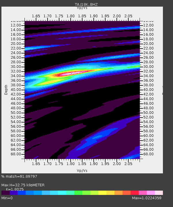
| Estimated Moho Depth: |
32.75 km |
| Estimated Crust Vp/Vs: |
1.80 |
| Assumed Crust Vp: |
6.182 km/s |
| Estimated Crust Vs: |
3.43 km/s |
| Estimated Crust Poisson's Ratio: |
0.28 |
|
| Radial Match: |
91.89797 % |
| Radial Bump: |
400 |
| Transverse Match: |
55.449177 % |
| Transverse Bump: |
400 |
| SOD ConfigId: |
13570011 |
| Insert Time: |
2019-04-30 21:56:59.513 +0000 |
| GWidth: |
2.5 |
| Max Bumps: |
400 |
| Tol: |
0.001 |
|

Signal To Noise
| Channel | StoN | STA | LTA |
| TA:J18K: :BHZ:20180819T04:40:02.025012Z | 7.9183164 | 2.751997E-6 | 3.4754825E-7 |
| TA:J18K: :BHN:20180819T04:40:02.025012Z | 4.205165 | 1.1867339E-6 | 2.8220865E-7 |
| TA:J18K: :BHE:20180819T04:40:02.025012Z | 1.418121 | 9.645609E-7 | 6.801682E-7 |
| Arrivals |
| Ps | 4.4 SECOND |
| PpPs | 15 SECOND |
| PsPs/PpSs | 19 SECOND |


