You are here: Home > Network List > TA - USArray Transportable Network (new EarthScope stations) Stations List
> Station Y17A Roosevelt, AZ, USA > Earthquake Result Viewer
Y17A Roosevelt, AZ, USA - Earthquake Result Viewer
| Earthquake location: |
Northern Mid-Atlantic Ridge |
| Earthquake latitude/longitude: |
52.4/-31.8 |
| Earthquake time(UTC): |
2007/05/23 (143) 04:41:46 GMT |
| Earthquake Depth: |
10 km |
| Earthquake Magnitude: |
5.6 MS, 5.4 MB, 5.7 MW, 5.6 MW |
| Earthquake Catalog/Contributor: |
WHDF/NEIC |
|
| Network: |
TA USArray Transportable Network (new EarthScope stations) |
| Station: |
Y17A Roosevelt, AZ, USA |
| Lat/Lon: |
33.70 N/110.84 W |
| Elevation: |
866 m |
|
| Distance: |
57.8 deg |
| Az: |
284.614 deg |
| Baz: |
45.391 deg |
| Ray Param: |
0.06328398 |
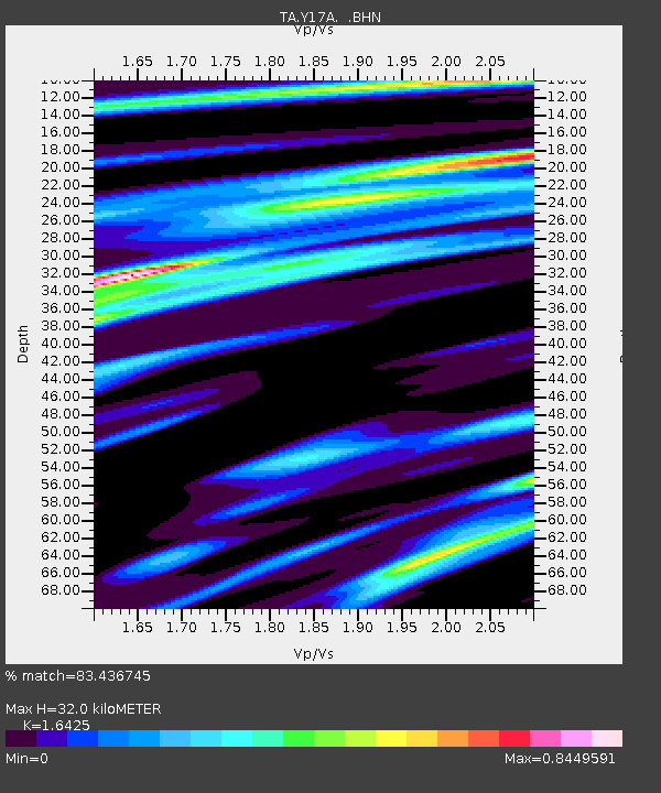
| Estimated Moho Depth: |
32.0 km |
| Estimated Crust Vp/Vs: |
1.64 |
| Assumed Crust Vp: |
6.276 km/s |
| Estimated Crust Vs: |
3.821 km/s |
| Estimated Crust Poisson's Ratio: |
0.21 |
|
| Radial Match: |
83.436745 % |
| Radial Bump: |
400 |
| Transverse Match: |
63.146828 % |
| Transverse Bump: |
400 |
| SOD ConfigId: |
2564 |
| Insert Time: |
2010-03-06 14:25:19.995 +0000 |
| GWidth: |
2.5 |
| Max Bumps: |
400 |
| Tol: |
0.001 |
|
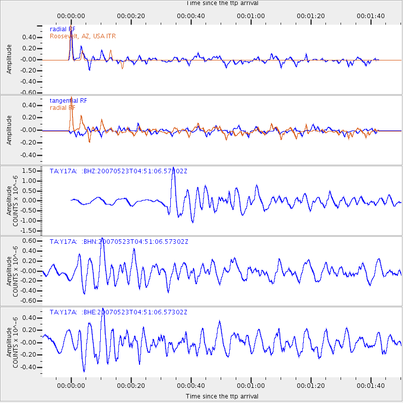
Signal To Noise
| Channel | StoN | STA | LTA |
| TA:Y17A: :BHN:20070523T04:51:06.57302Z | 2.1818614 | 2.3037508E-7 | 1.05586494E-7 |
| TA:Y17A: :BHE:20070523T04:51:06.57302Z | 2.3051667 | 2.0718998E-7 | 8.98807E-8 |
| TA:Y17A: :BHZ:20070523T04:51:06.57302Z | 6.029872 | 7.2171133E-7 | 1.1968932E-7 |
| Arrivals |
| Ps | 3.4 SECOND |
| PpPs | 13 SECOND |
| PsPs/PpSs | 16 SECOND |


