You are here: Home > Network List > TA - USArray Transportable Network (new EarthScope stations) Stations List
> Station L15K Ungalak Mountain, AK, USA > Earthquake Result Viewer
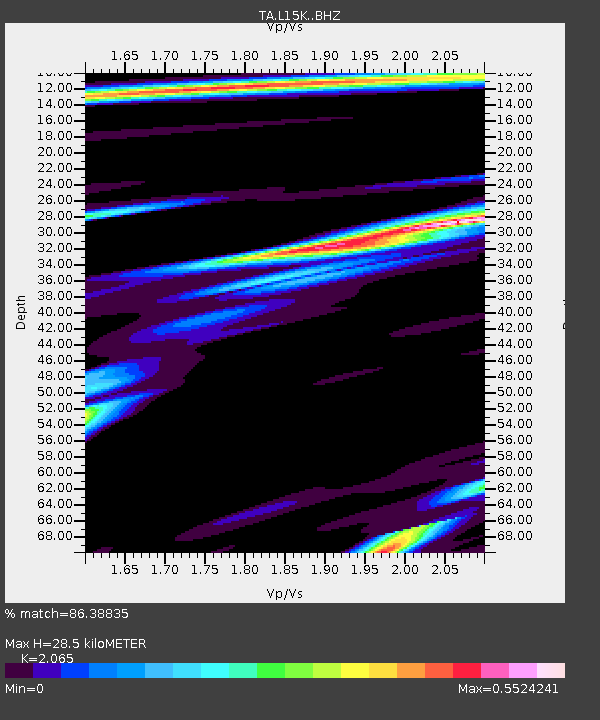
L15K Ungalak Mountain, AK, USA - Earthquake Result Viewer
| Earthquake location: |
Fiji Islands Region |
| Earthquake latitude/longitude: |
-17.0/-178.0 |
| Earthquake time(UTC): |
2018/08/19 (231) 04:28:58 GMT |
| Earthquake Depth: |
416 km |
| Earthquake Magnitude: |
6.8 mww |
| Earthquake Catalog/Contributor: |
NEIC PDE/us |
|
| Network: |
TA USArray Transportable Network (new EarthScope stations) |
| Station: |
L15K Ungalak Mountain, AK, USA |
| Lat/Lon: |
61.68 N/161.49 W |
| Elevation: |
219 m |
|
| Distance: |
79.5 deg |
| Az: |
7.94 deg |
| Baz: |
196.092 deg |
| Ray Param: |
0.0477566 |
| Estimated Moho Depth: |
28.5 km |
| Estimated Crust Vp/Vs: |
2.07 |
| Assumed Crust Vp: |
6.182 km/s |
| Estimated Crust Vs: |
2.994 km/s |
| Estimated Crust Poisson's Ratio: |
0.35 |
|
| Radial Match: |
86.38835 % |
| Radial Bump: |
255 |
| Transverse Match: |
55.03879 % |
| Transverse Bump: |
400 |
| SOD ConfigId: |
13570011 |
| Insert Time: |
2019-04-30 21:57:09.727 +0000 |
| GWidth: |
2.5 |
| Max Bumps: |
400 |
| Tol: |
0.001 |
|

Signal To Noise
| Channel | StoN | STA | LTA |
| TA:L15K: :BHZ:20180819T04:39:49.549976Z | 3.7751837 | 2.4153212E-6 | 6.3978905E-7 |
| TA:L15K: :BHN:20180819T04:39:49.549976Z | 2.137026 | 9.569467E-7 | 4.477936E-7 |
| TA:L15K: :BHE:20180819T04:39:49.549976Z | 1.2598842 | 6.907691E-7 | 5.4827984E-7 |
| Arrivals |
| Ps | 5.0 SECOND |
| PpPs | 14 SECOND |
| PsPs/PpSs | 19 SECOND |


