You are here: Home > Network List > TA - USArray Transportable Network (new EarthScope stations) Stations List
> Station P16K Nushagak River, AK, USA > Earthquake Result Viewer
P16K Nushagak River, AK, USA - Earthquake Result Viewer
| Earthquake location: |
Fiji Islands Region |
| Earthquake latitude/longitude: |
-17.0/-178.0 |
| Earthquake time(UTC): |
2018/08/19 (231) 04:28:58 GMT |
| Earthquake Depth: |
416 km |
| Earthquake Magnitude: |
6.8 mww |
| Earthquake Catalog/Contributor: |
NEIC PDE/us |
|
| Network: |
TA USArray Transportable Network (new EarthScope stations) |
| Station: |
P16K Nushagak River, AK, USA |
| Lat/Lon: |
59.03 N/157.99 W |
| Elevation: |
86 m |
|
| Distance: |
77.5 deg |
| Az: |
10.459 deg |
| Baz: |
199.629 deg |
| Ray Param: |
0.04908277 |
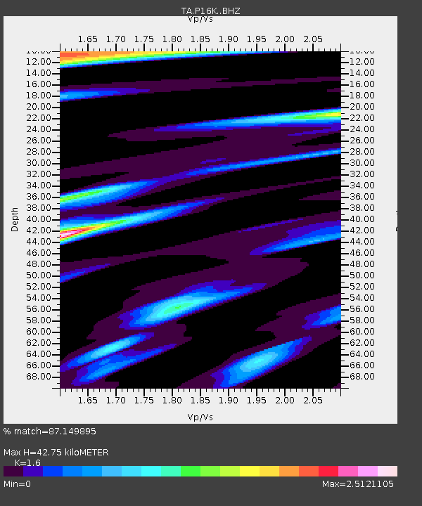
| Estimated Moho Depth: |
42.75 km |
| Estimated Crust Vp/Vs: |
1.60 |
| Assumed Crust Vp: |
6.276 km/s |
| Estimated Crust Vs: |
3.922 km/s |
| Estimated Crust Poisson's Ratio: |
0.18 |
|
| Radial Match: |
87.149895 % |
| Radial Bump: |
319 |
| Transverse Match: |
82.13175 % |
| Transverse Bump: |
340 |
| SOD ConfigId: |
13570011 |
| Insert Time: |
2019-04-30 21:57:39.346 +0000 |
| GWidth: |
2.5 |
| Max Bumps: |
400 |
| Tol: |
0.001 |
|

Signal To Noise
| Channel | StoN | STA | LTA |
| TA:P16K: :BHZ:20180819T04:39:38.825Z | 5.769102 | 5.550309E-6 | 9.620751E-7 |
| TA:P16K: :BHN:20180819T04:39:38.825Z | 1.4102151 | 2.525962E-6 | 1.791189E-6 |
| TA:P16K: :BHE:20180819T04:39:38.825Z | 1.6828052 | 2.759827E-6 | 1.640016E-6 |
| Arrivals |
| Ps | 4.2 SECOND |
| PpPs | 17 SECOND |
| PsPs/PpSs | 21 SECOND |


