You are here: Home > Network List > UW - Pacific Northwest Regional Seismic Network Stations List
> Station BLOW Detroit Lake, OR, USA > Earthquake Result Viewer
BLOW Detroit Lake, OR, USA - Earthquake Result Viewer
| Earthquake location: |
Fiji Islands Region |
| Earthquake latitude/longitude: |
-17.0/-178.0 |
| Earthquake time(UTC): |
2018/08/19 (231) 04:28:58 GMT |
| Earthquake Depth: |
416 km |
| Earthquake Magnitude: |
6.8 mww |
| Earthquake Catalog/Contributor: |
NEIC PDE/us |
|
| Network: |
UW Pacific Northwest Regional Seismic Network |
| Station: |
BLOW Detroit Lake, OR, USA |
| Lat/Lon: |
44.68 N/122.19 W |
| Elevation: |
652 m |
|
| Distance: |
79.6 deg |
| Az: |
36.878 deg |
| Baz: |
233.615 deg |
| Ray Param: |
0.047656294 |
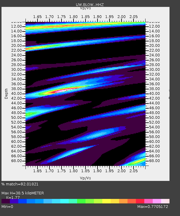
| Estimated Moho Depth: |
38.5 km |
| Estimated Crust Vp/Vs: |
1.77 |
| Assumed Crust Vp: |
6.566 km/s |
| Estimated Crust Vs: |
3.71 km/s |
| Estimated Crust Poisson's Ratio: |
0.27 |
|
| Radial Match: |
92.01821 % |
| Radial Bump: |
298 |
| Transverse Match: |
60.600098 % |
| Transverse Bump: |
400 |
| SOD ConfigId: |
13570011 |
| Insert Time: |
2019-04-30 21:58:52.991 +0000 |
| GWidth: |
2.5 |
| Max Bumps: |
400 |
| Tol: |
0.001 |
|

Signal To Noise
| Channel | StoN | STA | LTA |
| UW:BLOW: :HHZ:20180819T04:39:50.307971Z | 6.095952 | 2.348813E-6 | 3.8530703E-7 |
| UW:BLOW: :HHN:20180819T04:39:50.307971Z | 2.0749166 | 9.989992E-7 | 4.814648E-7 |
| UW:BLOW: :HHE:20180819T04:39:50.307971Z | 1.1740407 | 9.825068E-7 | 8.368593E-7 |
| Arrivals |
| Ps | 4.6 SECOND |
| PpPs | 16 SECOND |
| PsPs/PpSs | 20 SECOND |


