You are here: Home > Network List > UW - Pacific Northwest Regional Seismic Network Stations List
> Station H2O H2O, Hanford, WA, USA > Earthquake Result Viewer
H2O H2O, Hanford, WA, USA - Earthquake Result Viewer
| Earthquake location: |
Fiji Islands Region |
| Earthquake latitude/longitude: |
-17.0/-178.0 |
| Earthquake time(UTC): |
2018/08/19 (231) 04:28:58 GMT |
| Earthquake Depth: |
416 km |
| Earthquake Magnitude: |
6.8 mww |
| Earthquake Catalog/Contributor: |
NEIC PDE/us |
|
| Network: |
UW Pacific Northwest Regional Seismic Network |
| Station: |
H2O H2O, Hanford, WA, USA |
| Lat/Lon: |
46.40 N/119.42 W |
| Elevation: |
175 m |
|
| Distance: |
82.2 deg |
| Az: |
36.605 deg |
| Baz: |
235.538 deg |
| Ray Param: |
0.04590324 |
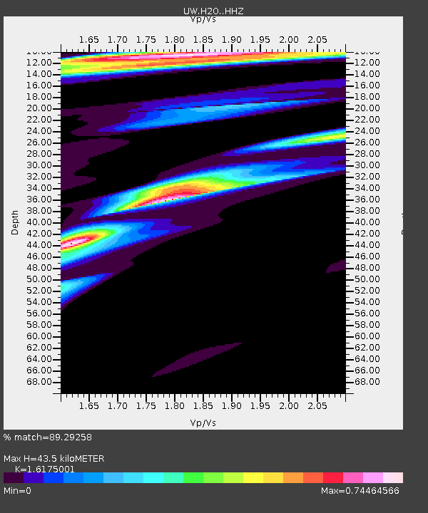
| Estimated Moho Depth: |
43.5 km |
| Estimated Crust Vp/Vs: |
1.62 |
| Assumed Crust Vp: |
6.419 km/s |
| Estimated Crust Vs: |
3.969 km/s |
| Estimated Crust Poisson's Ratio: |
0.19 |
|
| Radial Match: |
89.29258 % |
| Radial Bump: |
358 |
| Transverse Match: |
62.90071 % |
| Transverse Bump: |
400 |
| SOD ConfigId: |
13570011 |
| Insert Time: |
2019-04-30 21:59:01.394 +0000 |
| GWidth: |
2.5 |
| Max Bumps: |
400 |
| Tol: |
0.001 |
|

Signal To Noise
| Channel | StoN | STA | LTA |
| UW:H2O: :HHZ:20180819T04:40:03.669971Z | 6.321831 | 3.5827293E-6 | 5.667234E-7 |
| UW:H2O: :HHN:20180819T04:40:03.669971Z | 4.733568 | 1.0042024E-6 | 2.1214493E-7 |
| UW:H2O: :HHE:20180819T04:40:03.669971Z | 2.5207963 | 1.1347257E-6 | 4.5014573E-7 |
| Arrivals |
| Ps | 4.3 SECOND |
| PpPs | 17 SECOND |
| PsPs/PpSs | 22 SECOND |


