You are here: Home > Network List > UW - Pacific Northwest Regional Seismic Network Stations List
> Station LEBA Lebam, WA, USA > Earthquake Result Viewer
LEBA Lebam, WA, USA - Earthquake Result Viewer
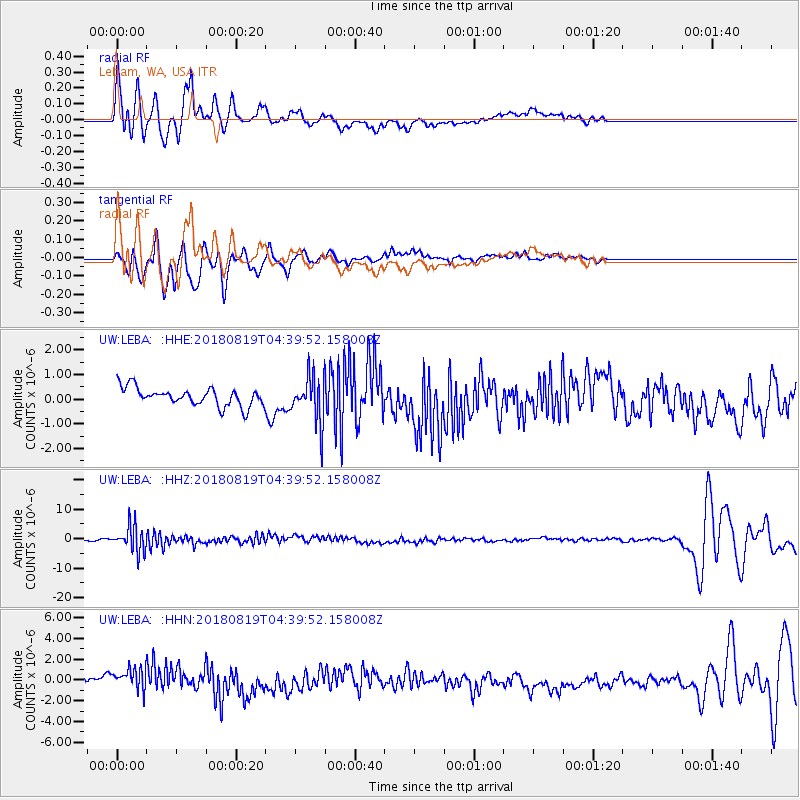
| Earthquake location: |
Fiji Islands Region |
| Earthquake latitude/longitude: |
-17.0/-178.0 |
| Earthquake time(UTC): |
2018/08/19 (231) 04:28:58 GMT |
| Earthquake Depth: |
416 km |
| Earthquake Magnitude: |
6.8 mww |
| Earthquake Catalog/Contributor: |
NEIC PDE/us |
|
| Network: |
UW Pacific Northwest Regional Seismic Network |
| Station: |
LEBA Lebam, WA, USA |
| Lat/Lon: |
46.55 N/123.56 W |
| Elevation: |
73 m |
|
| Distance: |
80.0 deg |
| Az: |
34.777 deg |
| Baz: |
232.263 deg |
| Ray Param: |
0.047416795 |
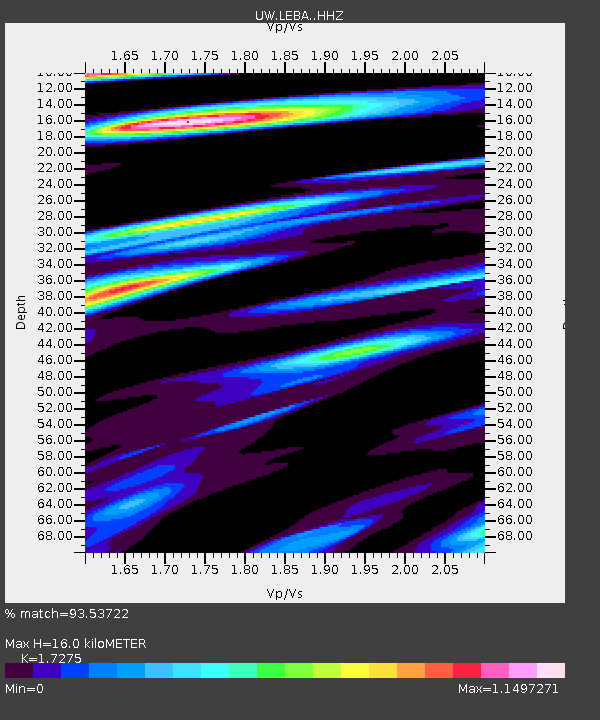
| Estimated Moho Depth: |
16.0 km |
| Estimated Crust Vp/Vs: |
1.73 |
| Assumed Crust Vp: |
6.566 km/s |
| Estimated Crust Vs: |
3.801 km/s |
| Estimated Crust Poisson's Ratio: |
0.25 |
|
| Radial Match: |
93.53722 % |
| Radial Bump: |
400 |
| Transverse Match: |
80.316605 % |
| Transverse Bump: |
400 |
| SOD ConfigId: |
13570011 |
| Insert Time: |
2019-04-30 21:59:08.585 +0000 |
| GWidth: |
2.5 |
| Max Bumps: |
400 |
| Tol: |
0.001 |
|
Signal To Noise
| Channel | StoN | STA | LTA |
| UW:LEBA: :HHZ:20180819T04:39:52.158008Z | 9.966785 | 4.371177E-6 | 4.3857446E-7 |
| UW:LEBA: :HHN:20180819T04:39:52.158008Z | 2.9165602 | 1.2117165E-6 | 4.1546082E-7 |
| UW:LEBA: :HHE:20180819T04:39:52.158008Z | 2.5024705 | 9.234259E-7 | 3.6900573E-7 |
| Arrivals |
| Ps | 1.8 SECOND |
| PpPs | 6.5 SECOND |
| PsPs/PpSs | 8.3 SECOND |


