You are here: Home > Network List > UW - Pacific Northwest Regional Seismic Network Stations List
> Station LON Longmire CREST broad-band > Earthquake Result Viewer
LON Longmire CREST broad-band - Earthquake Result Viewer
| Earthquake location: |
Fiji Islands Region |
| Earthquake latitude/longitude: |
-17.0/-178.0 |
| Earthquake time(UTC): |
2018/08/19 (231) 04:28:58 GMT |
| Earthquake Depth: |
416 km |
| Earthquake Magnitude: |
6.8 mww |
| Earthquake Catalog/Contributor: |
NEIC PDE/us |
|
| Network: |
UW Pacific Northwest Regional Seismic Network |
| Station: |
LON Longmire CREST broad-band |
| Lat/Lon: |
46.75 N/121.81 W |
| Elevation: |
853 m |
|
| Distance: |
81.1 deg |
| Az: |
35.349 deg |
| Baz: |
233.628 deg |
| Ray Param: |
0.046680573 |
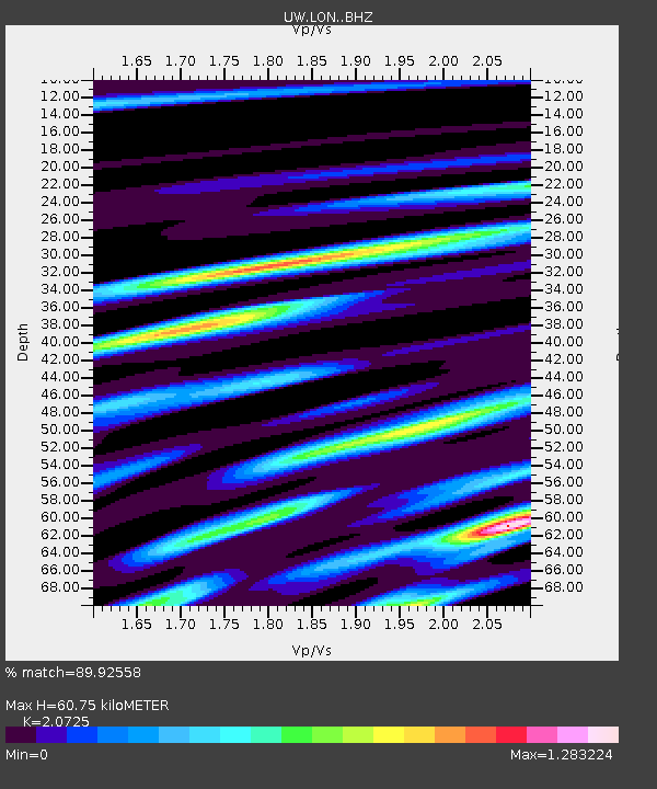
| Estimated Moho Depth: |
60.75 km |
| Estimated Crust Vp/Vs: |
2.07 |
| Assumed Crust Vp: |
6.597 km/s |
| Estimated Crust Vs: |
3.183 km/s |
| Estimated Crust Poisson's Ratio: |
0.35 |
|
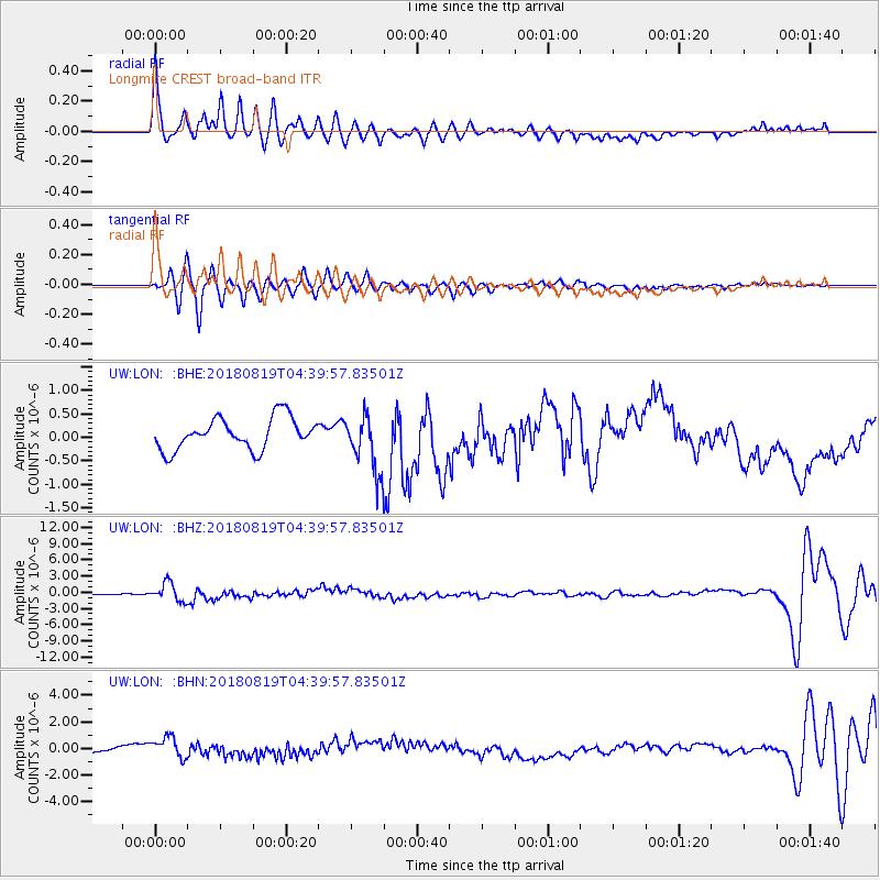
| Radial Match: |
89.92558 % |
| Radial Bump: |
400 |
| Transverse Match: |
84.44133 % |
| Transverse Bump: |
400 |
| SOD ConfigId: |
13570011 |
| Insert Time: |
2019-04-30 21:59:09.078 +0000 |
| GWidth: |
2.5 |
| Max Bumps: |
400 |
| Tol: |
0.001 |
|
Signal To Noise
| Channel | StoN | STA | LTA |
| UW:LON: :BHZ:20180819T04:39:57.83501Z | 2.9462218 | 1.6948519E-6 | 5.7526285E-7 |
| UW:LON: :BHN:20180819T04:39:57.83501Z | 3.1329653 | 8.364624E-7 | 2.6698746E-7 |
| UW:LON: :BHE:20180819T04:39:57.83501Z | 1.8331493 | 6.0846577E-7 | 3.3192373E-7 |
| Arrivals |
| Ps | 10 SECOND |
| PpPs | 28 SECOND |
| PsPs/PpSs | 38 SECOND |


