You are here: Home > Network List > UW - Pacific Northwest Regional Seismic Network Stations List
> Station PRO Prosser, WA, USA (was ISC code PRW) > Earthquake Result Viewer
PRO Prosser, WA, USA (was ISC code PRW) - Earthquake Result Viewer
| Earthquake location: |
Fiji Islands Region |
| Earthquake latitude/longitude: |
-17.0/-178.0 |
| Earthquake time(UTC): |
2018/08/19 (231) 04:28:58 GMT |
| Earthquake Depth: |
416 km |
| Earthquake Magnitude: |
6.8 mww |
| Earthquake Catalog/Contributor: |
NEIC PDE/us |
|
| Network: |
UW Pacific Northwest Regional Seismic Network |
| Station: |
PRO Prosser, WA, USA (was ISC code PRW) |
| Lat/Lon: |
46.21 N/119.69 W |
| Elevation: |
553 m |
|
| Distance: |
82.0 deg |
| Az: |
36.653 deg |
| Baz: |
235.355 deg |
| Ray Param: |
0.0460789 |
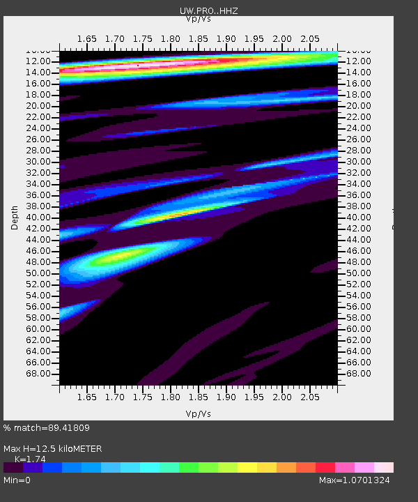
| Estimated Moho Depth: |
12.5 km |
| Estimated Crust Vp/Vs: |
1.74 |
| Assumed Crust Vp: |
6.419 km/s |
| Estimated Crust Vs: |
3.689 km/s |
| Estimated Crust Poisson's Ratio: |
0.25 |
|
| Radial Match: |
89.41809 % |
| Radial Bump: |
400 |
| Transverse Match: |
64.30041 % |
| Transverse Bump: |
400 |
| SOD ConfigId: |
13570011 |
| Insert Time: |
2019-04-30 21:59:17.393 +0000 |
| GWidth: |
2.5 |
| Max Bumps: |
400 |
| Tol: |
0.001 |
|

Signal To Noise
| Channel | StoN | STA | LTA |
| UW:PRO: :HHZ:20180819T04:40:02.369983Z | 5.3045516 | 2.835915E-6 | 5.346192E-7 |
| UW:PRO: :HHN:20180819T04:40:02.369983Z | 2.9426684 | 7.904696E-7 | 2.686234E-7 |
| UW:PRO: :HHE:20180819T04:40:02.369983Z | 3.8666499 | 1.1734077E-6 | 3.034688E-7 |
| Arrivals |
| Ps | 1.5 SECOND |
| PpPs | 5.2 SECOND |
| PsPs/PpSs | 6.7 SECOND |


