You are here: Home > Network List > UW - Pacific Northwest Regional Seismic Network Stations List
> Station WOLL Wollman Farm, Schrag, WA, USA > Earthquake Result Viewer
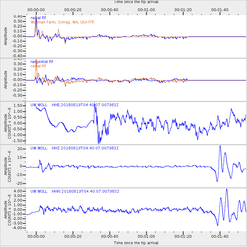
WOLL Wollman Farm, Schrag, WA, USA - Earthquake Result Viewer

| Earthquake location: |
Fiji Islands Region |
| Earthquake latitude/longitude: |
-17.0/-178.0 |
| Earthquake time(UTC): |
2018/08/19 (231) 04:28:58 GMT |
| Earthquake Depth: |
416 km |
| Earthquake Magnitude: |
6.8 mww |
| Earthquake Catalog/Contributor: |
NEIC PDE/us |
|
| Network: |
UW Pacific Northwest Regional Seismic Network |
| Station: |
WOLL Wollman Farm, Schrag, WA, USA |
| Lat/Lon: |
47.06 N/118.92 W |
| Elevation: |
385 m |
|
| Distance: |
82.9 deg |
| Az: |
36.251 deg |
| Baz: |
235.857 deg |
| Ray Param: |
0.045454346 |
| Estimated Moho Depth: |
29.5 km |
| Estimated Crust Vp/Vs: |
1.79 |
| Assumed Crust Vp: |
6.419 km/s |
| Estimated Crust Vs: |
3.586 km/s |
| Estimated Crust Poisson's Ratio: |
0.27 |
|
| Radial Match: |
91.95384 % |
| Radial Bump: |
366 |
| Transverse Match: |
75.13933 % |
| Transverse Bump: |
353 |
| SOD ConfigId: |
13570011 |
| Insert Time: |
2019-04-30 21:59:26.684 +0000 |
| GWidth: |
2.5 |
| Max Bumps: |
400 |
| Tol: |
0.001 |
|
Signal To Noise
| Channel | StoN | STA | LTA |
| UW:WOLL: :HHZ:20180819T04:40:07.007983Z | 7.0691214 | 3.5258436E-6 | 4.987669E-7 |
| UW:WOLL: :HHN:20180819T04:40:07.007983Z | 1.0769148 | 4.867016E-7 | 4.519407E-7 |
| UW:WOLL: :HHE:20180819T04:40:07.007983Z | 1.2843817 | 8.7284684E-7 | 6.7958524E-7 |
| Arrivals |
| Ps | 3.7 SECOND |
| PpPs | 13 SECOND |
| PsPs/PpSs | 16 SECOND |


