You are here: Home > Network List > GE - GEOFON Stations List
> Station SNAA GEOFON/AWI Station Sanae, Antarctica > Earthquake Result Viewer
SNAA GEOFON/AWI Station Sanae, Antarctica - Earthquake Result Viewer
| Earthquake location: |
Sumbawa Region, Indonesia |
| Earthquake latitude/longitude: |
-8.3/116.6 |
| Earthquake time(UTC): |
2018/08/19 (231) 14:56:28 GMT |
| Earthquake Depth: |
26 km |
| Earthquake Magnitude: |
6.9 Mww |
| Earthquake Catalog/Contributor: |
NEIC PDE/us |
|
| Network: |
GE GEOFON |
| Station: |
SNAA GEOFON/AWI Station Sanae, Antarctica |
| Lat/Lon: |
71.67 S/2.84 W |
| Elevation: |
846 m |
|
| Distance: |
91.0 deg |
| Az: |
195.992 deg |
| Baz: |
120.486 deg |
| Ray Param: |
0.04163019 |
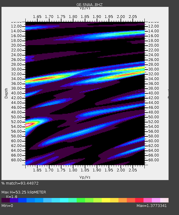
| Estimated Moho Depth: |
53.25 km |
| Estimated Crust Vp/Vs: |
1.60 |
| Assumed Crust Vp: |
6.43 km/s |
| Estimated Crust Vs: |
4.019 km/s |
| Estimated Crust Poisson's Ratio: |
0.18 |
|
| Radial Match: |
93.44872 % |
| Radial Bump: |
400 |
| Transverse Match: |
84.709984 % |
| Transverse Bump: |
400 |
| SOD ConfigId: |
13570011 |
| Insert Time: |
2019-04-30 22:01:23.940 +0000 |
| GWidth: |
2.5 |
| Max Bumps: |
400 |
| Tol: |
0.001 |
|
Signal To Noise
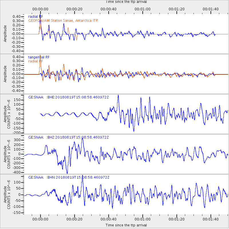
| Channel | StoN | STA | LTA |
| GE:SNAA: :BHZ:20180819T15:08:58.460972Z | 6.646171 | 9.3007846E-5 | 1.39942E-5 |
| GE:SNAA: :BHN:20180819T15:08:58.460972Z | 1.7416025 | 1.3638139E-5 | 7.8307985E-6 |
| GE:SNAA: :BHE:20180819T15:08:58.460972Z | 2.5231545 | 3.2681583E-5 | 1.2952669E-5 |
| Arrivals |
| Ps | 5.1 SECOND |
| PpPs | 21 SECOND |
| PsPs/PpSs | 26 SECOND |


