You are here: Home > Network List > JP - Japan Meteorological Agency Seismic Network Stations List
> Station JGF Gifu Kurokawa > Earthquake Result Viewer
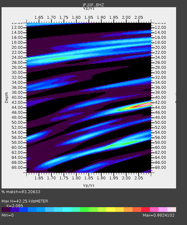
JGF Gifu Kurokawa - Earthquake Result Viewer
| Earthquake location: |
Sumbawa Region, Indonesia |
| Earthquake latitude/longitude: |
-8.3/116.6 |
| Earthquake time(UTC): |
2018/08/19 (231) 14:56:28 GMT |
| Earthquake Depth: |
26 km |
| Earthquake Magnitude: |
6.9 Mww |
| Earthquake Catalog/Contributor: |
NEIC PDE/us |
|
| Network: |
JP Japan Meteorological Agency Seismic Network |
| Station: |
JGF Gifu Kurokawa |
| Lat/Lon: |
35.60 N/137.35 E |
| Elevation: |
580 m |
|
| Distance: |
47.9 deg |
| Az: |
22.889 deg |
| Baz: |
208.185 deg |
| Ray Param: |
0.0696788 |
| Estimated Moho Depth: |
42.25 km |
| Estimated Crust Vp/Vs: |
2.10 |
| Assumed Crust Vp: |
6.461 km/s |
| Estimated Crust Vs: |
3.084 km/s |
| Estimated Crust Poisson's Ratio: |
0.35 |
|
| Radial Match: |
93.20633 % |
| Radial Bump: |
400 |
| Transverse Match: |
81.569565 % |
| Transverse Bump: |
400 |
| SOD ConfigId: |
13570011 |
| Insert Time: |
2019-04-30 22:01:42.839 +0000 |
| GWidth: |
2.5 |
| Max Bumps: |
400 |
| Tol: |
0.001 |
|

Signal To Noise
| Channel | StoN | STA | LTA |
| JP:JGF: :BHZ:20180819T15:04:33.000004Z | 6.3776436 | 1.9186075E-6 | 3.0083328E-7 |
| JP:JGF: :BHN:20180819T15:04:33.000004Z | 4.6588836 | 9.687033E-7 | 2.0792606E-7 |
| JP:JGF: :BHE:20180819T15:04:33.000004Z | 3.628721 | 6.7683396E-7 | 1.8652136E-7 |
| Arrivals |
| Ps | 7.5 SECOND |
| PpPs | 19 SECOND |
| PsPs/PpSs | 27 SECOND |


