You are here: Home > Network List > TA - USArray Transportable Network (new EarthScope stations) Stations List
> Station Y17A Roosevelt, AZ, USA > Earthquake Result Viewer
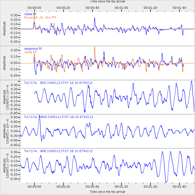
Y17A Roosevelt, AZ, USA - Earthquake Result Viewer
*The percent match for this event was below the threshold and hence no stack was calculated.
| Earthquake location: |
Solomon Islands |
| Earthquake latitude/longitude: |
-8.9/159.6 |
| Earthquake time(UTC): |
2008/11/21 (326) 07:05:34 GMT |
| Earthquake Depth: |
118 km |
| Earthquake Magnitude: |
6.0 MB, 6.1 MW, 6.0 MW |
| Earthquake Catalog/Contributor: |
WHDF/NEIC |
|
| Network: |
TA USArray Transportable Network (new EarthScope stations) |
| Station: |
Y17A Roosevelt, AZ, USA |
| Lat/Lon: |
33.70 N/110.84 W |
| Elevation: |
866 m |
|
| Distance: |
94.6 deg |
| Az: |
56.756 deg |
| Baz: |
262.356 deg |
| Ray Param: |
$rayparam |
*The percent match for this event was below the threshold and hence was not used in the summary stack. |
|
| Radial Match: |
62.86924 % |
| Radial Bump: |
400 |
| Transverse Match: |
55.554844 % |
| Transverse Bump: |
400 |
| SOD ConfigId: |
2658 |
| Insert Time: |
2010-03-06 14:26:22.815 +0000 |
| GWidth: |
2.5 |
| Max Bumps: |
400 |
| Tol: |
0.001 |
|
Signal To Noise
| Channel | StoN | STA | LTA |
| TA:Y17A: :BHN:20081121T07:18:10.874021Z | 2.1927507 | 4.3278928E-7 | 1.9737277E-7 |
| TA:Y17A: :BHE:20081121T07:18:10.874021Z | 0.94298154 | 1.07414905E-7 | 1.1390987E-7 |
| TA:Y17A: :BHZ:20081121T07:18:10.874021Z | 1.3330748 | 1.481957E-7 | 1.1116833E-7 |
| Arrivals |
| Ps | |
| PpPs | |
| PsPs/PpSs | |


