You are here: Home > Network List > S - Seismographs in Schools Projects Stations List
> Station AUPHS Peel High School, NSW, Australia > Earthquake Result Viewer
AUPHS Peel High School, NSW, Australia - Earthquake Result Viewer
| Earthquake location: |
Sumbawa Region, Indonesia |
| Earthquake latitude/longitude: |
-8.3/116.6 |
| Earthquake time(UTC): |
2018/08/19 (231) 14:56:28 GMT |
| Earthquake Depth: |
26 km |
| Earthquake Magnitude: |
6.9 Mww |
| Earthquake Catalog/Contributor: |
NEIC PDE/us |
|
| Network: |
S Seismographs in Schools Projects |
| Station: |
AUPHS Peel High School, NSW, Australia |
| Lat/Lon: |
31.10 S/150.89 E |
| Elevation: |
404 m |
|
| Distance: |
39.2 deg |
| Az: |
130.096 deg |
| Baz: |
298.055 deg |
| Ray Param: |
0.07510625 |
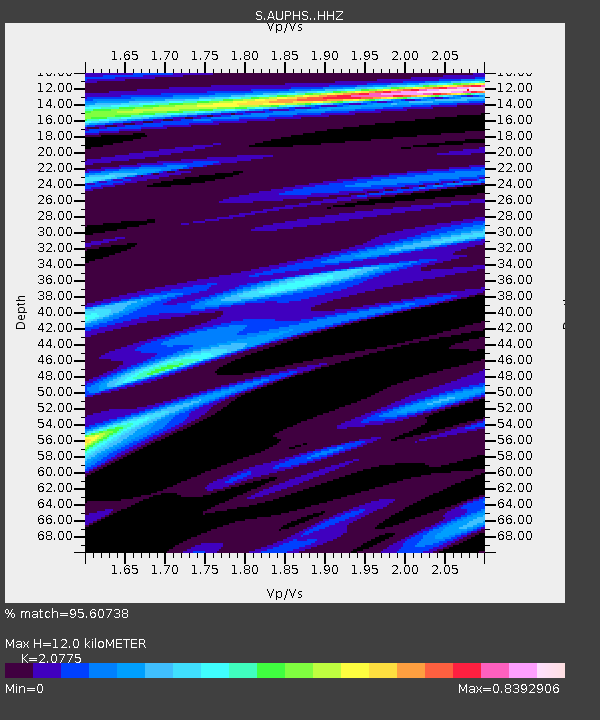
| Estimated Moho Depth: |
12.0 km |
| Estimated Crust Vp/Vs: |
2.08 |
| Assumed Crust Vp: |
6.577 km/s |
| Estimated Crust Vs: |
3.166 km/s |
| Estimated Crust Poisson's Ratio: |
0.35 |
|
| Radial Match: |
95.60738 % |
| Radial Bump: |
276 |
| Transverse Match: |
62.708195 % |
| Transverse Bump: |
400 |
| SOD ConfigId: |
13570011 |
| Insert Time: |
2019-04-30 22:02:51.460 +0000 |
| GWidth: |
2.5 |
| Max Bumps: |
400 |
| Tol: |
0.001 |
|

Signal To Noise
| Channel | StoN | STA | LTA |
| S:AUPHS: :HHZ:20180819T15:03:22.840Z | 8.167535 | 2.9399748E-6 | 3.5995865E-7 |
| S:AUPHS: :HHN:20180819T15:03:22.840Z | 4.634215 | 1.2016753E-6 | 2.5930507E-7 |
| S:AUPHS: :HHE:20180819T15:03:22.840Z | 2.3319345 | 1.3807155E-6 | 5.920902E-7 |
| Arrivals |
| Ps | 2.1 SECOND |
| PpPs | 5.3 SECOND |
| PsPs/PpSs | 7.4 SECOND |


