You are here: Home > Network List > TA - USArray Transportable Network (new EarthScope stations) Stations List
> Station F22K John River, AK, USA > Earthquake Result Viewer
F22K John River, AK, USA - Earthquake Result Viewer
| Earthquake location: |
Sumbawa Region, Indonesia |
| Earthquake latitude/longitude: |
-8.3/116.6 |
| Earthquake time(UTC): |
2018/08/19 (231) 14:56:28 GMT |
| Earthquake Depth: |
26 km |
| Earthquake Magnitude: |
6.9 Mww |
| Earthquake Catalog/Contributor: |
NEIC PDE/us |
|
| Network: |
TA USArray Transportable Network (new EarthScope stations) |
| Station: |
F22K John River, AK, USA |
| Lat/Lon: |
67.51 N/152.18 W |
| Elevation: |
546 m |
|
| Distance: |
98.1 deg |
| Az: |
22.864 deg |
| Baz: |
267.9 deg |
| Ray Param: |
0.04000145 |
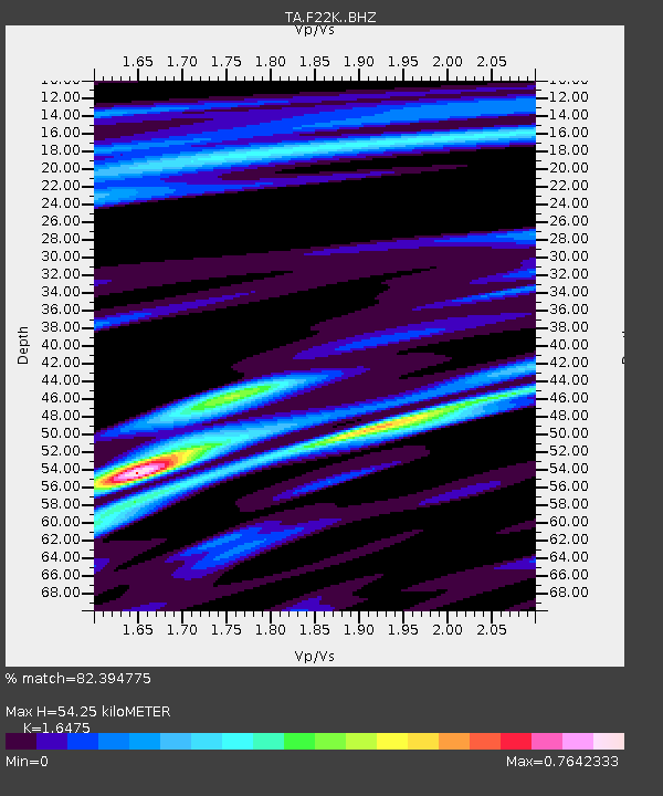
| Estimated Moho Depth: |
54.25 km |
| Estimated Crust Vp/Vs: |
1.65 |
| Assumed Crust Vp: |
6.455 km/s |
| Estimated Crust Vs: |
3.918 km/s |
| Estimated Crust Poisson's Ratio: |
0.21 |
|
| Radial Match: |
82.394775 % |
| Radial Bump: |
400 |
| Transverse Match: |
65.656815 % |
| Transverse Bump: |
400 |
| SOD ConfigId: |
13570011 |
| Insert Time: |
2019-04-30 22:03:04.946 +0000 |
| GWidth: |
2.5 |
| Max Bumps: |
400 |
| Tol: |
0.001 |
|

Signal To Noise
| Channel | StoN | STA | LTA |
| TA:F22K: :BHZ:20180819T15:09:30.649998Z | 2.0363595 | 2.5127449E-7 | 1.2339397E-7 |
| TA:F22K: :BHN:20180819T15:09:30.649998Z | 0.92430276 | 9.172863E-8 | 9.9240886E-8 |
| TA:F22K: :BHE:20180819T15:09:30.649998Z | 0.79907954 | 1.04654774E-7 | 1.3096917E-7 |
| Arrivals |
| Ps | 5.6 SECOND |
| PpPs | 22 SECOND |
| PsPs/PpSs | 27 SECOND |


