You are here: Home > Network List > TA - USArray Transportable Network (new EarthScope stations) Stations List
> Station G17K Kiwalik Mountain, AK, USA > Earthquake Result Viewer
G17K Kiwalik Mountain, AK, USA - Earthquake Result Viewer
| Earthquake location: |
Sumbawa Region, Indonesia |
| Earthquake latitude/longitude: |
-8.3/116.6 |
| Earthquake time(UTC): |
2018/08/19 (231) 14:56:28 GMT |
| Earthquake Depth: |
26 km |
| Earthquake Magnitude: |
6.9 Mww |
| Earthquake Catalog/Contributor: |
NEIC PDE/us |
|
| Network: |
TA USArray Transportable Network (new EarthScope stations) |
| Station: |
G17K Kiwalik Mountain, AK, USA |
| Lat/Lon: |
65.50 N/160.65 W |
| Elevation: |
338 m |
|
| Distance: |
94.5 deg |
| Az: |
24.513 deg |
| Baz: |
259.954 deg |
| Ray Param: |
0.04102059 |
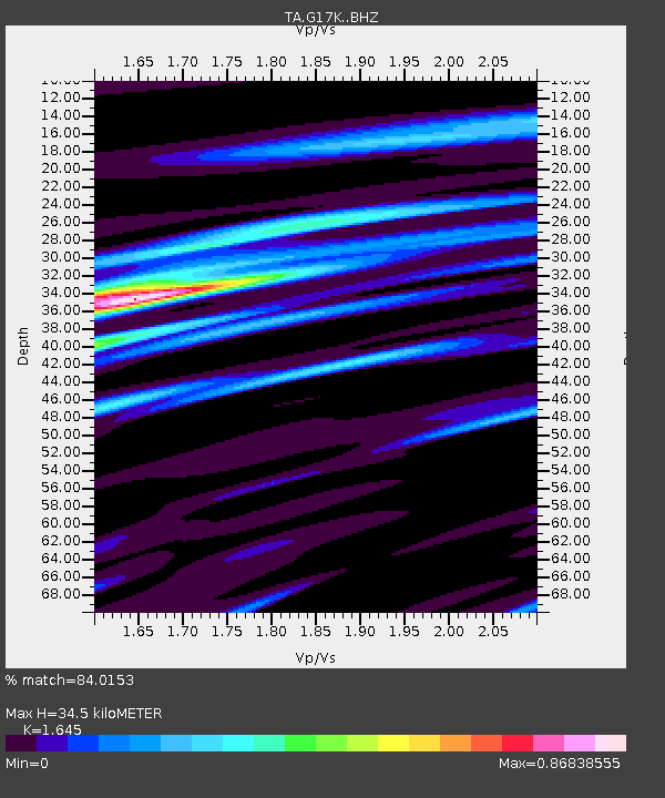
| Estimated Moho Depth: |
34.5 km |
| Estimated Crust Vp/Vs: |
1.64 |
| Assumed Crust Vp: |
6.276 km/s |
| Estimated Crust Vs: |
3.815 km/s |
| Estimated Crust Poisson's Ratio: |
0.21 |
|
| Radial Match: |
84.0153 % |
| Radial Bump: |
400 |
| Transverse Match: |
61.607708 % |
| Transverse Bump: |
400 |
| SOD ConfigId: |
13570011 |
| Insert Time: |
2019-04-30 22:03:06.024 +0000 |
| GWidth: |
2.5 |
| Max Bumps: |
400 |
| Tol: |
0.001 |
|

Signal To Noise
| Channel | StoN | STA | LTA |
| TA:G17K: :BHZ:20180819T15:09:14.524998Z | 2.7181816 | 3.8184226E-7 | 1.4047708E-7 |
| TA:G17K: :BHN:20180819T15:09:14.524998Z | 0.9067724 | 1.385004E-7 | 1.5273999E-7 |
| TA:G17K: :BHE:20180819T15:09:14.524998Z | 1.3377689 | 1.820474E-7 | 1.3608285E-7 |
| Arrivals |
| Ps | 3.6 SECOND |
| PpPs | 14 SECOND |
| PsPs/PpSs | 18 SECOND |


