You are here: Home > Network List > TJ - Tajikistan National Seismic Network Stations List
> Station GARM Garm, Tajikistan > Earthquake Result Viewer
GARM Garm, Tajikistan - Earthquake Result Viewer
| Earthquake location: |
Sumbawa Region, Indonesia |
| Earthquake latitude/longitude: |
-8.3/116.6 |
| Earthquake time(UTC): |
2018/08/19 (231) 14:56:28 GMT |
| Earthquake Depth: |
26 km |
| Earthquake Magnitude: |
6.9 Mww |
| Earthquake Catalog/Contributor: |
NEIC PDE/us |
|
| Network: |
TJ Tajikistan National Seismic Network |
| Station: |
GARM Garm, Tajikistan |
| Lat/Lon: |
39.00 N/70.32 E |
| Elevation: |
1305 m |
|
| Distance: |
63.7 deg |
| Az: |
321.076 deg |
| Baz: |
127.066 deg |
| Ray Param: |
0.05934735 |
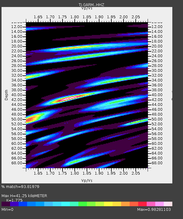
| Estimated Moho Depth: |
41.25 km |
| Estimated Crust Vp/Vs: |
1.77 |
| Assumed Crust Vp: |
6.306 km/s |
| Estimated Crust Vs: |
3.553 km/s |
| Estimated Crust Poisson's Ratio: |
0.27 |
|
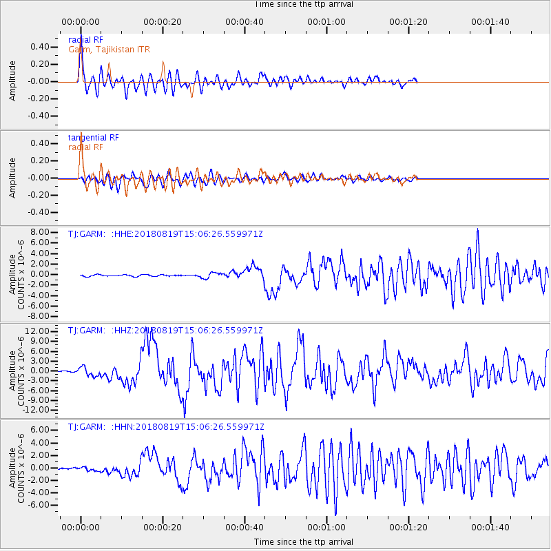
| Radial Match: |
93.81979 % |
| Radial Bump: |
400 |
| Transverse Match: |
84.15303 % |
| Transverse Bump: |
400 |
| SOD ConfigId: |
13570011 |
| Insert Time: |
2019-04-30 22:03:20.222 +0000 |
| GWidth: |
2.5 |
| Max Bumps: |
400 |
| Tol: |
0.001 |
|
Signal To Noise
| Channel | StoN | STA | LTA |
| TJ:GARM: :HHZ:20180819T15:06:26.559971Z | 12.024787 | 1.3138476E-6 | 1.09261606E-7 |
| TJ:GARM: :HHN:20180819T15:06:26.559971Z | 1.8808974 | 2.7463986E-7 | 1.4601534E-7 |
| TJ:GARM: :HHE:20180819T15:06:26.559971Z | 3.5550754 | 5.3364766E-7 | 1.5010868E-7 |
| Arrivals |
| Ps | 5.3 SECOND |
| PpPs | 17 SECOND |
| PsPs/PpSs | 23 SECOND |


