You are here: Home > Network List > YT07 - POLENET Stations List
> Station WAIS WAIS > Earthquake Result Viewer
WAIS WAIS - Earthquake Result Viewer
| Earthquake location: |
Sumbawa Region, Indonesia |
| Earthquake latitude/longitude: |
-8.3/116.6 |
| Earthquake time(UTC): |
2018/08/19 (231) 14:56:28 GMT |
| Earthquake Depth: |
26 km |
| Earthquake Magnitude: |
6.9 Mww |
| Earthquake Catalog/Contributor: |
NEIC PDE/us |
|
| Network: |
YT POLENET |
| Station: |
WAIS WAIS |
| Lat/Lon: |
79.42 S/111.78 W |
| Elevation: |
1800 m |
|
| Distance: |
88.9 deg |
| Az: |
172.053 deg |
| Baz: |
227.749 deg |
| Ray Param: |
0.04224483 |
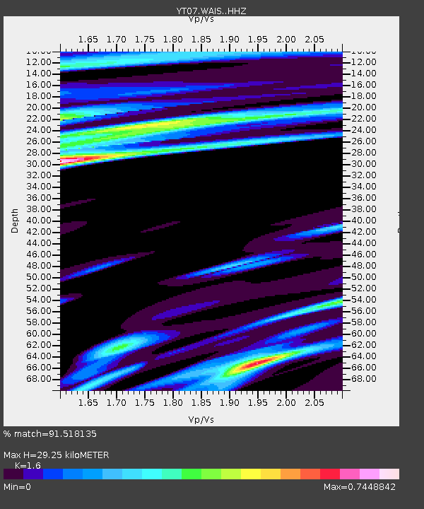
| Estimated Moho Depth: |
29.25 km |
| Estimated Crust Vp/Vs: |
1.60 |
| Assumed Crust Vp: |
5.833 km/s |
| Estimated Crust Vs: |
3.646 km/s |
| Estimated Crust Poisson's Ratio: |
0.18 |
|
| Radial Match: |
91.518135 % |
| Radial Bump: |
400 |
| Transverse Match: |
88.76651 % |
| Transverse Bump: |
400 |
| SOD ConfigId: |
13570011 |
| Insert Time: |
2019-04-30 22:03:39.109 +0000 |
| GWidth: |
2.5 |
| Max Bumps: |
400 |
| Tol: |
0.001 |
|

Signal To Noise
| Channel | StoN | STA | LTA |
| YT:WAIS: :HHZ:20180819T15:08:48.449985Z | 10.436834 | 2.5929426E-6 | 2.4844147E-7 |
| YT:WAIS: :HHN:20180819T15:08:48.449985Z | 2.2322679 | 4.7703725E-7 | 2.1370072E-7 |
| YT:WAIS: :HHE:20180819T15:08:48.449985Z | 3.902508 | 7.153089E-7 | 1.8329466E-7 |
| Arrivals |
| Ps | 3.1 SECOND |
| PpPs | 13 SECOND |
| PsPs/PpSs | 16 SECOND |


