You are here: Home > Network List > TA - USArray Transportable Network (new EarthScope stations) Stations List
> Station B18K Kokolik River, AK, USA > Earthquake Result Viewer
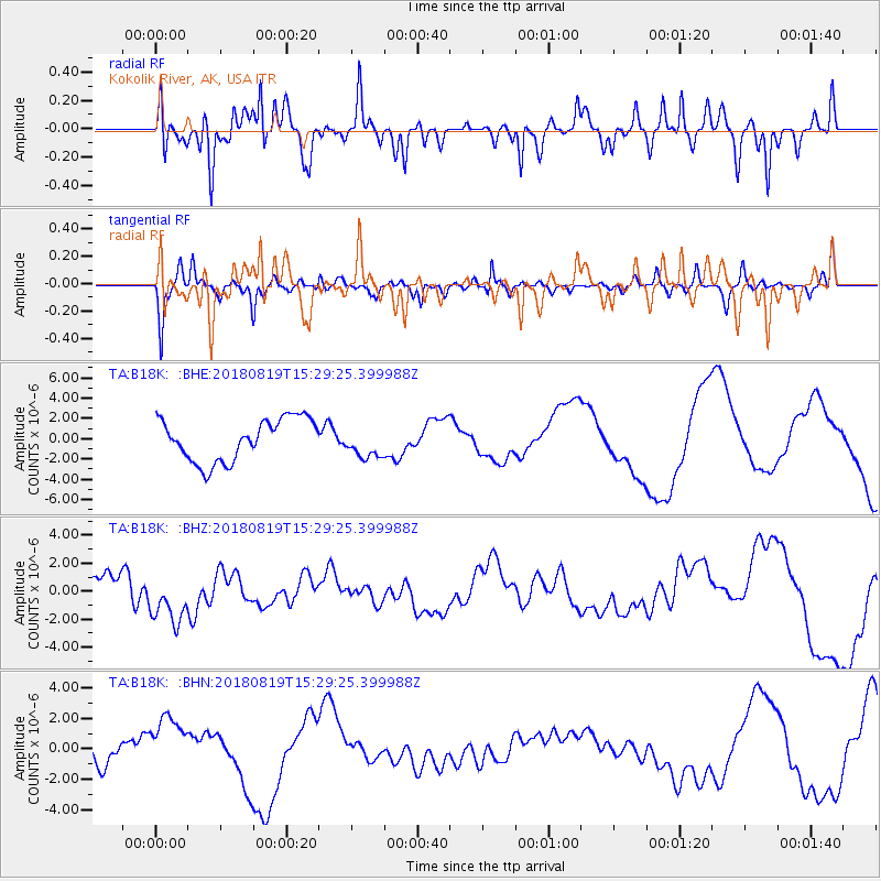
B18K Kokolik River, AK, USA - Earthquake Result Viewer
*The percent match for this event was below the threshold and hence no stack was calculated.
| Earthquake location: |
Sumbawa Region, Indonesia |
| Earthquake latitude/longitude: |
-8.4/116.6 |
| Earthquake time(UTC): |
2018/08/19 (231) 15:16:34 GMT |
| Earthquake Depth: |
10 km |
| Earthquake Magnitude: |
5.9 mb |
| Earthquake Catalog/Contributor: |
NEIC PDE/us |
|
| Network: |
TA USArray Transportable Network (new EarthScope stations) |
| Station: |
B18K Kokolik River, AK, USA |
| Lat/Lon: |
69.36 N/161.80 W |
| Elevation: |
222 m |
|
| Distance: |
94.9 deg |
| Az: |
20.607 deg |
| Baz: |
259.191 deg |
| Ray Param: |
$rayparam |
*The percent match for this event was below the threshold and hence was not used in the summary stack. |
|
| Radial Match: |
37.09474 % |
| Radial Bump: |
347 |
| Transverse Match: |
57.990868 % |
| Transverse Bump: |
352 |
| SOD ConfigId: |
13570011 |
| Insert Time: |
2019-04-30 22:08:26.517 +0000 |
| GWidth: |
2.5 |
| Max Bumps: |
400 |
| Tol: |
0.001 |
|
Signal To Noise
| Channel | StoN | STA | LTA |
| TA:B18K: :BHZ:20180819T15:29:25.399988Z | 0.7866819 | 1.5822632E-6 | 2.0113125E-6 |
| TA:B18K: :BHN:20180819T15:29:25.399988Z | 2.3732717 | 1.9445997E-6 | 8.1937515E-7 |
| TA:B18K: :BHE:20180819T15:29:25.399988Z | 0.625008 | 1.312049E-6 | 2.0992516E-6 |
| Arrivals |
| Ps | |
| PpPs | |
| PsPs/PpSs | |


