You are here: Home > Network List > TA - USArray Transportable Network (new EarthScope stations) Stations List
> Station T19A Beclabito, NM, USA > Earthquake Result Viewer
T19A Beclabito, NM, USA - Earthquake Result Viewer
| Earthquake location: |
Fiji Islands Region |
| Earthquake latitude/longitude: |
-17.3/-177.3 |
| Earthquake time(UTC): |
2008/07/19 (201) 22:39:52 GMT |
| Earthquake Depth: |
391 km |
| Earthquake Magnitude: |
5.9 MB, 6.4 MW, 6.4 MW |
| Earthquake Catalog/Contributor: |
WHDF/NEIC |
|
| Network: |
TA USArray Transportable Network (new EarthScope stations) |
| Station: |
T19A Beclabito, NM, USA |
| Lat/Lon: |
36.83 N/109.02 W |
| Elevation: |
1736 m |
|
| Distance: |
83.9 deg |
| Az: |
48.564 deg |
| Baz: |
243.185 deg |
| Ray Param: |
0.044835154 |
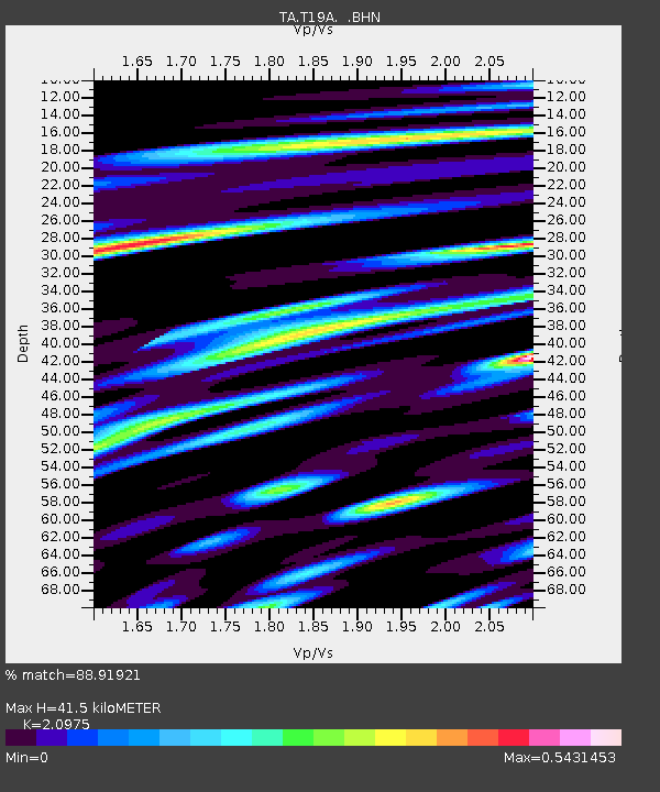
| Estimated Moho Depth: |
41.5 km |
| Estimated Crust Vp/Vs: |
2.10 |
| Assumed Crust Vp: |
6.476 km/s |
| Estimated Crust Vs: |
3.087 km/s |
| Estimated Crust Poisson's Ratio: |
0.35 |
|
| Radial Match: |
88.91921 % |
| Radial Bump: |
400 |
| Transverse Match: |
77.24014 % |
| Transverse Bump: |
400 |
| SOD ConfigId: |
2504 |
| Insert Time: |
2010-03-06 14:26:55.357 +0000 |
| GWidth: |
2.5 |
| Max Bumps: |
400 |
| Tol: |
0.001 |
|
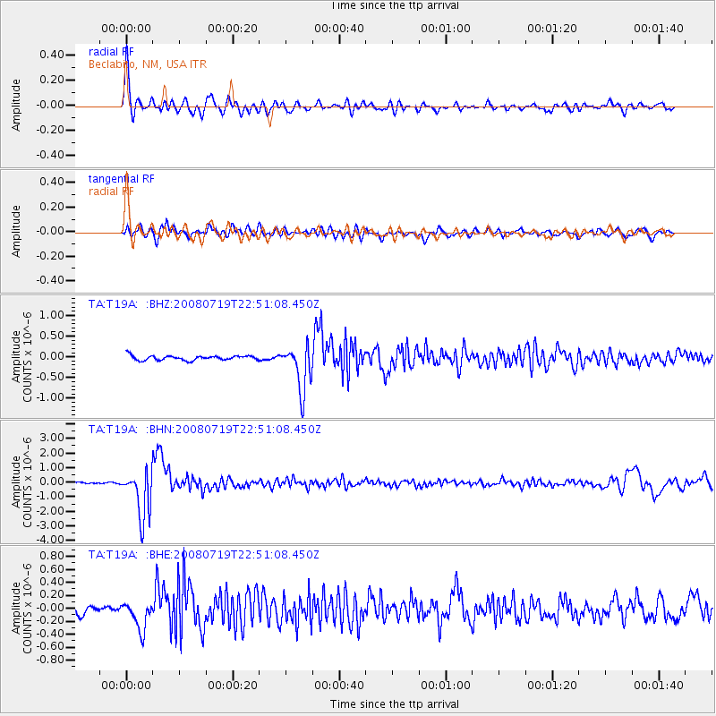
Signal To Noise
| Channel | StoN | STA | LTA |
| TA:T19A: :BHN:20080719T22:51:08.450Z | 28.679155 | 1.6436996E-6 | 5.731339E-8 |
| TA:T19A: :BHE:20080719T22:51:08.450Z | 2.365155 | 2.197903E-7 | 9.29285E-8 |
| TA:T19A: :BHZ:20080719T22:51:08.450Z | 10.124928 | 5.60329E-7 | 5.5341527E-8 |
| Arrivals |
| Ps | 7.2 SECOND |
| PpPs | 19 SECOND |
| PsPs/PpSs | 27 SECOND |


