You are here: Home > Network List > TA - USArray Transportable Network (new EarthScope stations) Stations List
> Station T19A Beclabito, NM, USA > Earthquake Result Viewer
T19A Beclabito, NM, USA - Earthquake Result Viewer
| Earthquake location: |
Kuril Islands |
| Earthquake latitude/longitude: |
51.0/157.6 |
| Earthquake time(UTC): |
2008/07/24 (206) 01:43:16 GMT |
| Earthquake Depth: |
27 km |
| Earthquake Magnitude: |
6.0 MB, 6.0 MS, 6.2 MW, 6.2 MW |
| Earthquake Catalog/Contributor: |
WHDF/NEIC |
|
| Network: |
TA USArray Transportable Network (new EarthScope stations) |
| Station: |
T19A Beclabito, NM, USA |
| Lat/Lon: |
36.83 N/109.02 W |
| Elevation: |
1736 m |
|
| Distance: |
64.4 deg |
| Az: |
62.656 deg |
| Baz: |
315.57 deg |
| Ray Param: |
0.058920488 |
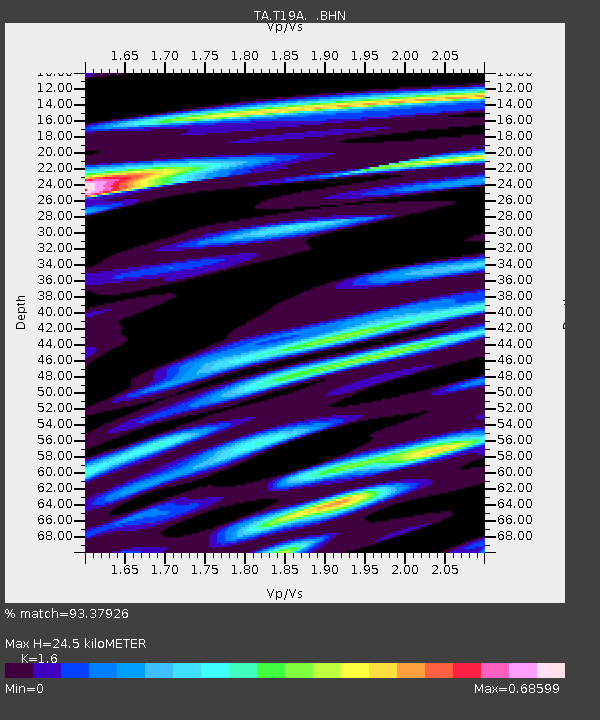
| Estimated Moho Depth: |
24.5 km |
| Estimated Crust Vp/Vs: |
1.60 |
| Assumed Crust Vp: |
6.476 km/s |
| Estimated Crust Vs: |
4.047 km/s |
| Estimated Crust Poisson's Ratio: |
0.18 |
|
| Radial Match: |
93.37926 % |
| Radial Bump: |
400 |
| Transverse Match: |
84.04886 % |
| Transverse Bump: |
400 |
| SOD ConfigId: |
2504 |
| Insert Time: |
2010-03-06 14:26:56.594 +0000 |
| GWidth: |
2.5 |
| Max Bumps: |
400 |
| Tol: |
0.001 |
|

Signal To Noise
| Channel | StoN | STA | LTA |
| TA:T19A: :BHN:20080724T01:53:18.65001Z | 20.152052 | 1.6687376E-6 | 8.2807325E-8 |
| TA:T19A: :BHE:20080724T01:53:18.65001Z | 8.511206 | 8.1572193E-7 | 9.5840946E-8 |
| TA:T19A: :BHZ:20080724T01:53:18.65001Z | 9.752059 | 7.5664207E-7 | 7.7587934E-8 |
| Arrivals |
| Ps | 2.4 SECOND |
| PpPs | 9.4 SECOND |
| PsPs/PpSs | 12 SECOND |


