You are here: Home > Network List > TA - USArray Transportable Network (new EarthScope stations) Stations List
> Station O15K Ungalikthiuk River, AK, USA > Earthquake Result Viewer
O15K Ungalikthiuk River, AK, USA - Earthquake Result Viewer
| Earthquake location: |
Sumbawa Region, Indonesia |
| Earthquake latitude/longitude: |
-8.4/116.6 |
| Earthquake time(UTC): |
2018/08/19 (231) 15:28:58 GMT |
| Earthquake Depth: |
10 km |
| Earthquake Magnitude: |
5.5 mb |
| Earthquake Catalog/Contributor: |
NEIC PDE/us |
|
| Network: |
TA USArray Transportable Network (new EarthScope stations) |
| Station: |
O15K Ungalikthiuk River, AK, USA |
| Lat/Lon: |
59.18 N/159.82 W |
| Elevation: |
306 m |
|
| Distance: |
93.9 deg |
| Az: |
30.859 deg |
| Baz: |
260.227 deg |
| Ray Param: |
0.04116677 |
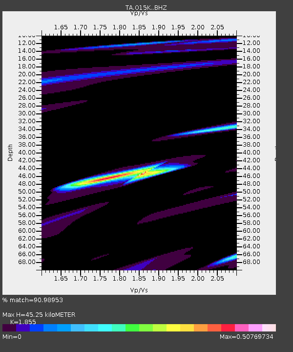
| Estimated Moho Depth: |
45.25 km |
| Estimated Crust Vp/Vs: |
1.86 |
| Assumed Crust Vp: |
6.24 km/s |
| Estimated Crust Vs: |
3.364 km/s |
| Estimated Crust Poisson's Ratio: |
0.30 |
|
| Radial Match: |
90.98953 % |
| Radial Bump: |
400 |
| Transverse Match: |
49.28899 % |
| Transverse Bump: |
400 |
| SOD ConfigId: |
13570011 |
| Insert Time: |
2019-04-30 22:11:04.176 +0000 |
| GWidth: |
2.5 |
| Max Bumps: |
400 |
| Tol: |
0.001 |
|

Signal To Noise
| Channel | StoN | STA | LTA |
| TA:O15K: :BHZ:20180819T15:41:44.77501Z | 0.39007124 | 1.4422044E-6 | 3.6972847E-6 |
| TA:O15K: :BHN:20180819T15:41:44.77501Z | 2.217317 | 2.552205E-6 | 1.1510328E-6 |
| TA:O15K: :BHE:20180819T15:41:44.77501Z | 1.5827569 | 2.8193808E-6 | 1.7813101E-6 |
| Arrivals |
| Ps | 6.3 SECOND |
| PpPs | 20 SECOND |
| PsPs/PpSs | 27 SECOND |


