You are here: Home > Network List > IU - Global Seismograph Network (GSN - IRIS/USGS) Stations List
> Station SLBS Sierra la Laguna Baja California Sur, Mexico > Earthquake Result Viewer
SLBS Sierra la Laguna Baja California Sur, Mexico - Earthquake Result Viewer
| Earthquake location: |
Fiji Islands |
| Earthquake latitude/longitude: |
-17.2/178.3 |
| Earthquake time(UTC): |
2009/11/09 (313) 10:44:54 GMT |
| Earthquake Depth: |
591 km |
| Earthquake Magnitude: |
6.6 MB, 7.3 MW, 7.2 MW |
| Earthquake Catalog/Contributor: |
WHDF/NEIC |
|
| Network: |
IU Global Seismograph Network (GSN - IRIS/USGS) |
| Station: |
SLBS Sierra la Laguna Baja California Sur, Mexico |
| Lat/Lon: |
23.69 N/109.94 W |
| Elevation: |
825 m |
|
| Distance: |
81.0 deg |
| Az: |
61.817 deg |
| Baz: |
246.758 deg |
| Ray Param: |
0.04611434 |
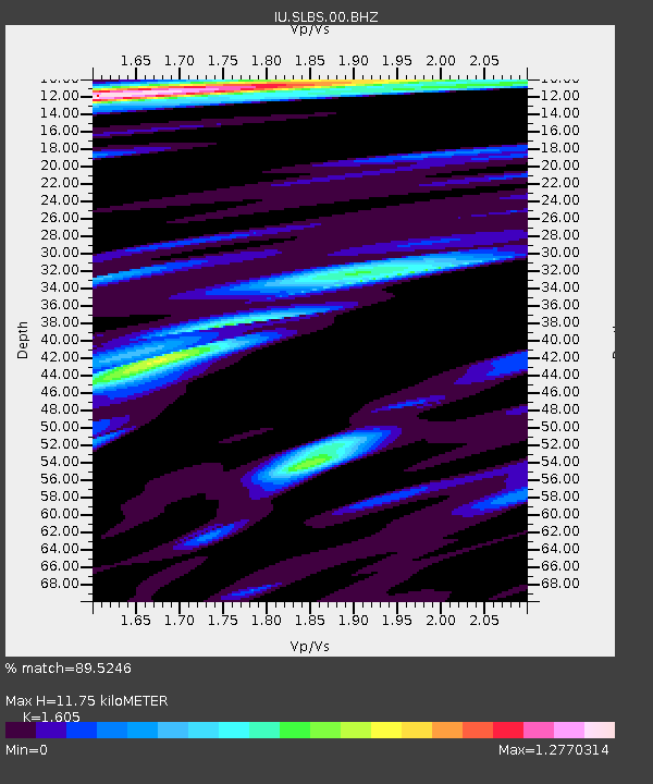
| Estimated Moho Depth: |
11.75 km |
| Estimated Crust Vp/Vs: |
1.61 |
| Assumed Crust Vp: |
6.183 km/s |
| Estimated Crust Vs: |
3.852 km/s |
| Estimated Crust Poisson's Ratio: |
0.18 |
|
| Radial Match: |
89.5246 % |
| Radial Bump: |
400 |
| Transverse Match: |
90.61929 % |
| Transverse Bump: |
400 |
| SOD ConfigId: |
1 |
| Insert Time: |
2010-02-19 01:08:40.200 +0000 |
| GWidth: |
2.5 |
| Max Bumps: |
400 |
| Tol: |
0.001 |
|

Signal To Noise
| Channel | StoN | STA | LTA |
| IU:SLBS:00:BHZ:20091109T10:55:37.470012Z | 9.468214 | 4.725878E-6 | 4.991309E-7 |
| IU:SLBS:00:BHN:20091109T10:55:37.470012Z | 3.1443295 | 8.4244516E-7 | 2.679252E-7 |
| IU:SLBS:00:BHE:20091109T10:55:37.470012Z | 3.629065 | 1.3363668E-6 | 3.6823997E-7 |
| Arrivals |
| Ps | 1.2 SECOND |
| PpPs | 4.8 SECOND |
| PsPs/PpSs | 6.0 SECOND |


