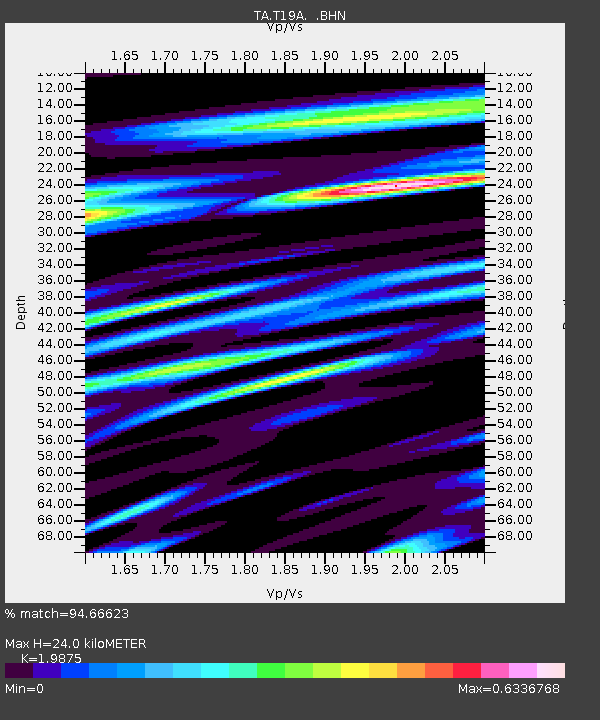
T19A Beclabito, NM, USA - Earthquake Result Viewer
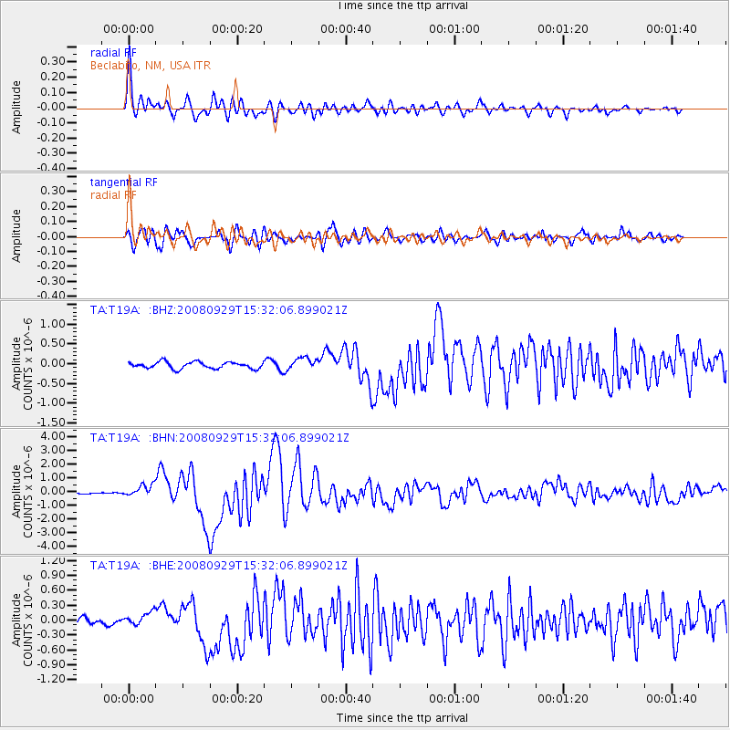
Earthquake location: Kermadec Islands, New Zealand
Earthquake latitude/longitude: -29.8/-177.7
Earthquake time(UTC): 2008/09/29 (273) 15:19:31 GMT
Earthquake Depth: 36 km
Earthquake Magnitude: 6.5 MB, 6.7 MS, 7.0 MW, 7.0 MW
Earthquake Catalog/Contributor: WHDF/NEIC
Network: TA USArray Transportable Network (new EarthScope stations)
Station: T19A Beclabito, NM, USA
Lat/Lon: 36.83 N/109.02 W
Elevation: 1736 m
Distance: 92.3 deg
Az: 48.413 deg
Baz: 234.157 deg
Ray Param: 0.041463513
Estimated Moho Depth: 24.0 km
Estimated Crust Vp/Vs: 1.99
Assumed Crust Vp: 6.476 km/s
Estimated Crust Vs: 3.258 km/s
Estimated Crust Poisson's Ratio: 0.33
Radial Match: 94.66623 %
Radial Bump: 400
Transverse Match: 87.876884 %
Transverse Bump: 400
SOD ConfigId: 2560
Insert Time: 2010-03-06 14:27:11.769 +0000
GWidth: 2.5
Max Bumps: 400
Tol: 0.001

Signal To Noise

ChannelStoNSTALTA
TA:T19A: :BHN:20080929T15:32:06.899021Z10.5092254.322282E-74.112846E-8
TA:T19A: :BHE:20080929T15:32:06.899021Z2.0474231.4405377E-77.035859E-8
TA:T19A: :BHZ:20080929T15:32:06.899021Z1.81612051.5186053E-78.361809E-8
Arrivals
Ps3.7 SECOND
PpPs11 SECOND
PsPs/PpSs15 SECOND