You are here: Home > Network List > TA - USArray Transportable Network (new EarthScope stations) Stations List
> Station T19A Beclabito, NM, USA > Earthquake Result Viewer
T19A Beclabito, NM, USA - Earthquake Result Viewer
| Earthquake location: |
Near Coast Of Northern Chile |
| Earthquake latitude/longitude: |
-22.9/-70.4 |
| Earthquake time(UTC): |
2007/11/15 (319) 15:03:08 GMT |
| Earthquake Depth: |
27 km |
| Earthquake Magnitude: |
5.8 MB, 6.1 MW, 5.5 ML |
| Earthquake Catalog/Contributor: |
WHDF/NEIC |
|
| Network: |
TA USArray Transportable Network (new EarthScope stations) |
| Station: |
T19A Beclabito, NM, USA |
| Lat/Lon: |
36.83 N/109.02 W |
| Elevation: |
1736 m |
|
| Distance: |
69.7 deg |
| Az: |
327.72 deg |
| Baz: |
142.125 deg |
| Ray Param: |
0.05546296 |
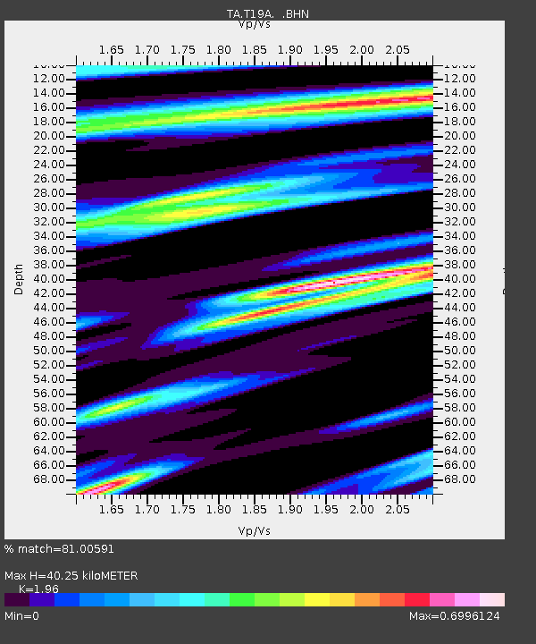
| Estimated Moho Depth: |
40.25 km |
| Estimated Crust Vp/Vs: |
1.96 |
| Assumed Crust Vp: |
6.476 km/s |
| Estimated Crust Vs: |
3.304 km/s |
| Estimated Crust Poisson's Ratio: |
0.32 |
|
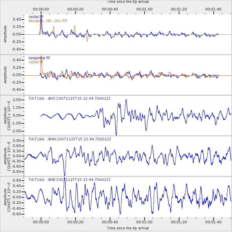
| Radial Match: |
81.00591 % |
| Radial Bump: |
366 |
| Transverse Match: |
72.24481 % |
| Transverse Bump: |
385 |
| SOD ConfigId: |
2564 |
| Insert Time: |
2010-03-06 14:27:35.720 +0000 |
| GWidth: |
2.5 |
| Max Bumps: |
400 |
| Tol: |
0.001 |
|
Signal To Noise
| Channel | StoN | STA | LTA |
| TA:T19A: :BHN:20071115T15:13:44.700012Z | 1.7224349 | 2.0014858E-7 | 1.1620096E-7 |
| TA:T19A: :BHE:20071115T15:13:44.700012Z | 1.4174955 | 1.9086305E-7 | 1.3464809E-7 |
| TA:T19A: :BHZ:20071115T15:13:44.700012Z | 1.7908837 | 3.9672528E-7 | 2.2152489E-7 |
| Arrivals |
| Ps | 6.2 SECOND |
| PpPs | 18 SECOND |
| PsPs/PpSs | 24 SECOND |


