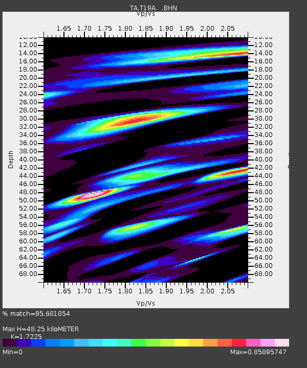
T19A Beclabito, NM, USA - Earthquake Result Viewer

Earthquake location: Andreanof Islands, Aleutian Is.
Earthquake latitude/longitude: 51.9/-179.2
Earthquake time(UTC): 2008/04/16 (107) 05:54:19 GMT
Earthquake Depth: 13 km
Earthquake Magnitude: 6.1 MB, 6.5 MS, 6.6 MW, 6.6 MW
Earthquake Catalog/Contributor: WHDF/NEIC
Network: TA USArray Transportable Network (new EarthScope stations)
Station: T19A Beclabito, NM, USA
Lat/Lon: 36.83 N/109.02 W
Elevation: 1736 m
Distance: 50.4 deg
Az: 78.312 deg
Baz: 310.835 deg
Ray Param: 0.06806975
Estimated Moho Depth: 48.25 km
Estimated Crust Vp/Vs: 1.72
Assumed Crust Vp: 6.476 km/s
Estimated Crust Vs: 3.76 km/s
Estimated Crust Poisson's Ratio: 0.25
Radial Match: 95.681854 %
Radial Bump: 400
Transverse Match: 90.09215 %
Transverse Bump: 400
SOD ConfigId: 2504
Insert Time: 2010-03-06 14:27:51.543 +0000
GWidth: 2.5
Max Bumps: 400
Tol: 0.001

Signal To Noise

ChannelStoNSTALTA
TA:T19A: :BHN:20080416T06:02:45.70001Z12.7599511.923601E-61.5075301E-7
TA:T19A: :BHE:20080416T06:02:45.70001Z5.8790264.7868554E-78.142259E-8
TA:T19A: :BHZ:20080416T06:02:45.70001Z3.23086145.7752345E-71.7875216E-7
Arrivals
Ps5.7 SECOND
PpPs19 SECOND
PsPs/PpSs25 SECOND