You are here: Home > Network List > TA - USArray Transportable Network (new EarthScope stations) Stations List
> Station G22K Bettles, AK, USA > Earthquake Result Viewer
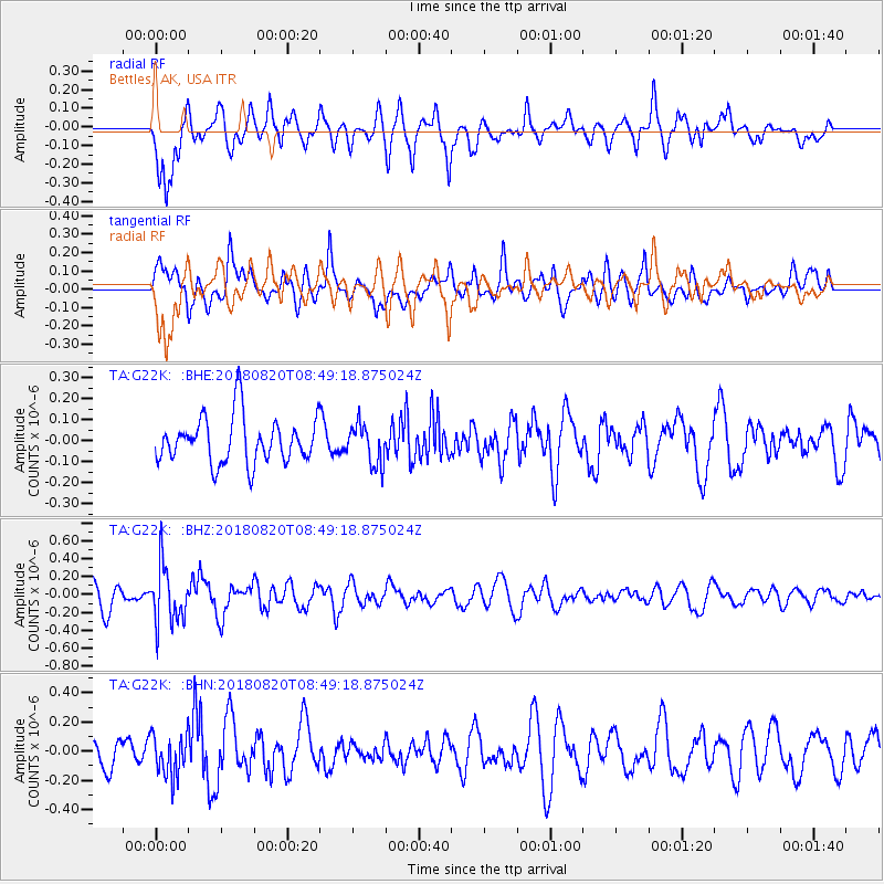
G22K Bettles, AK, USA - Earthquake Result Viewer
*The percent match for this event was below the threshold and hence no stack was calculated.
| Earthquake location: |
Fiji Islands Region |
| Earthquake latitude/longitude: |
-18.2/-178.2 |
| Earthquake time(UTC): |
2018/08/20 (232) 08:38:00 GMT |
| Earthquake Depth: |
528 km |
| Earthquake Magnitude: |
5.5 Mww |
| Earthquake Catalog/Contributor: |
NEIC PDE/us |
|
| Network: |
TA USArray Transportable Network (new EarthScope stations) |
| Station: |
G22K Bettles, AK, USA |
| Lat/Lon: |
66.92 N/151.51 W |
| Elevation: |
205 m |
|
| Distance: |
87.2 deg |
| Az: |
10.203 deg |
| Baz: |
205.278 deg |
| Ray Param: |
$rayparam |
*The percent match for this event was below the threshold and hence was not used in the summary stack. |
|
| Radial Match: |
71.73523 % |
| Radial Bump: |
400 |
| Transverse Match: |
60.056843 % |
| Transverse Bump: |
400 |
| SOD ConfigId: |
13570011 |
| Insert Time: |
2019-04-30 22:17:05.501 +0000 |
| GWidth: |
2.5 |
| Max Bumps: |
400 |
| Tol: |
0.001 |
|
Signal To Noise
| Channel | StoN | STA | LTA |
| TA:G22K: :BHZ:20180820T08:49:18.875024Z | 2.4769845 | 3.2037582E-7 | 1.2934107E-7 |
| TA:G22K: :BHN:20180820T08:49:18.875024Z | 1.0708678 | 1.4332922E-7 | 1.33844E-7 |
| TA:G22K: :BHE:20180820T08:49:18.875024Z | 0.8563826 | 9.4471964E-8 | 1.10315135E-7 |
| Arrivals |
| Ps | |
| PpPs | |
| PsPs/PpSs | |


