You are here: Home > Network List > TA - USArray Transportable Network (new EarthScope stations) Stations List
> Station P17K Kvichak River, AK, USA > Earthquake Result Viewer
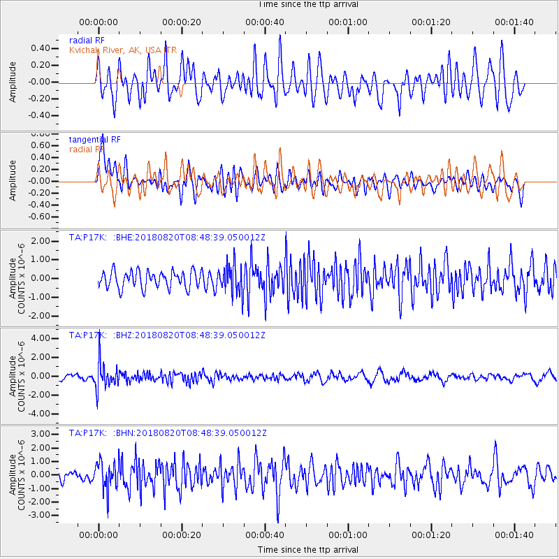
P17K Kvichak River, AK, USA - Earthquake Result Viewer
*The percent match for this event was below the threshold and hence no stack was calculated.
| Earthquake location: |
Fiji Islands Region |
| Earthquake latitude/longitude: |
-18.2/-178.2 |
| Earthquake time(UTC): |
2018/08/20 (232) 08:38:00 GMT |
| Earthquake Depth: |
528 km |
| Earthquake Magnitude: |
5.5 Mww |
| Earthquake Catalog/Contributor: |
NEIC PDE/us |
|
| Network: |
TA USArray Transportable Network (new EarthScope stations) |
| Station: |
P17K Kvichak River, AK, USA |
| Lat/Lon: |
59.20 N/156.44 W |
| Elevation: |
91 m |
|
| Distance: |
79.2 deg |
| Az: |
11.187 deg |
| Baz: |
200.994 deg |
| Ray Param: |
$rayparam |
*The percent match for this event was below the threshold and hence was not used in the summary stack. |
|
| Radial Match: |
61.129925 % |
| Radial Bump: |
400 |
| Transverse Match: |
58.549137 % |
| Transverse Bump: |
400 |
| SOD ConfigId: |
13570011 |
| Insert Time: |
2019-04-30 22:17:43.501 +0000 |
| GWidth: |
2.5 |
| Max Bumps: |
400 |
| Tol: |
0.001 |
|
Signal To Noise
| Channel | StoN | STA | LTA |
| TA:P17K: :BHZ:20180820T08:48:39.050012Z | 4.9825377 | 1.4807588E-6 | 2.9718967E-7 |
| TA:P17K: :BHN:20180820T08:48:39.050012Z | 2.2761745 | 1.0379187E-6 | 4.559926E-7 |
| TA:P17K: :BHE:20180820T08:48:39.050012Z | 1.734243 | 7.7422965E-7 | 4.4643667E-7 |
| Arrivals |
| Ps | |
| PpPs | |
| PsPs/PpSs | |


