You are here: Home > Network List > US - United States National Seismic Network Stations List
> Station MSO Missoula, Montana, USA > Earthquake Result Viewer
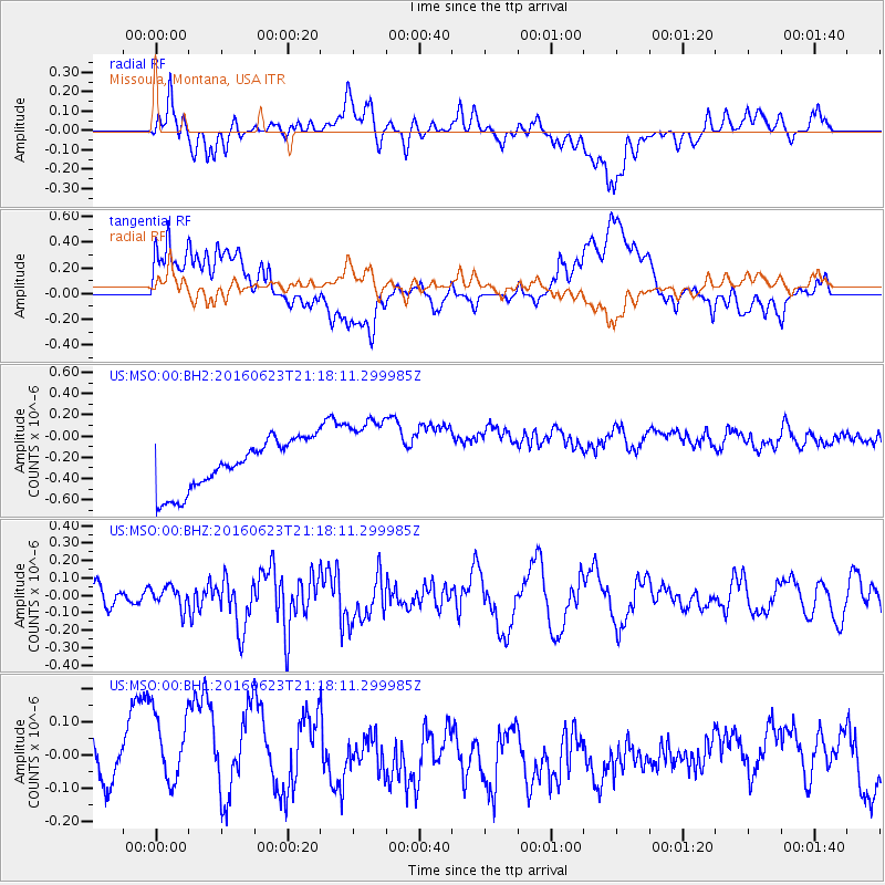
MSO Missoula, Montana, USA - Earthquake Result Viewer
*The percent match for this event was below the threshold and hence no stack was calculated.
| Earthquake location: |
Southwestern Ryukyu Isl., Japan |
| Earthquake latitude/longitude: |
23.6/123.4 |
| Earthquake time(UTC): |
2016/06/23 (175) 21:05:29 GMT |
| Earthquake Depth: |
10 km |
| Earthquake Magnitude: |
5.9 MWP |
| Earthquake Catalog/Contributor: |
NEIC PDE/NEIC COMCAT |
|
| Network: |
US United States National Seismic Network |
| Station: |
MSO Missoula, Montana, USA |
| Lat/Lon: |
46.83 N/113.94 W |
| Elevation: |
1264 m |
|
| Distance: |
92.9 deg |
| Az: |
35.359 deg |
| Baz: |
309.369 deg |
| Ray Param: |
$rayparam |
*The percent match for this event was below the threshold and hence was not used in the summary stack. |
|
| Radial Match: |
38.30231 % |
| Radial Bump: |
400 |
| Transverse Match: |
22.108133 % |
| Transverse Bump: |
400 |
| SOD ConfigId: |
1634031 |
| Insert Time: |
2016-07-07 21:10:36.826 +0000 |
| GWidth: |
2.5 |
| Max Bumps: |
400 |
| Tol: |
0.001 |
|
Signal To Noise
| Channel | StoN | STA | LTA |
| US:MSO:00:BHZ:20160623T21:18:11.299985Z | 0.9400882 | 6.1257396E-8 | 6.516133E-8 |
| US:MSO:00:BH1:20160623T21:18:11.299985Z | 1.39281 | 2.2339697E-7 | 1.60393E-7 |
| US:MSO:00:BH2:20160623T21:18:11.299985Z | 1.6242994 | 3.8105946E-7 | 2.3459927E-7 |
| Arrivals |
| Ps | |
| PpPs | |
| PsPs/PpSs | |


